Upernivik Island
| Upernivik Ø | |
|---|---|
 Upernivik | |
| Geography | |
| Location | Uummannaq Fjord |
| Coordinates | 71°16′N 52°45′W / 71.267°N 52.750°WCoordinates: 71°16′N 52°45′W / 71.267°N 52.750°W |
| Area | 540 km2 (210 sq mi) |
| Length | 30 km (19 mi) |
| Width | 24.4 km (15.16 mi) |
| Highest elevation | 1,903 m (6,243 ft) |
| Highest point | Palup Qaqa |
| Administration | |
| Municipality | Qaasuitsup |
Upernivik Island (Danish: Upernivik Ø) is an uninhabited[1] island in the Qaasuitsup municipality in northwestern Greenland.
Geography
Upernivik Island is located in the Uummannaq Fjord where it is the largest island with an area of 540 km2 (208.5 sq mi).[1]
The island is very mountainous.[2] Its highest point is Palup Qaqaa, an ultra-prominent peak at 71°20′17″N 72°48′17″W / 71.33806°N 72.80472°W reaching 1,903.47 m (6,245.0 ft).[3]
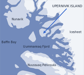 Location of Upernivik Island. |
 Aerial view of southwestern Upernivik Island |
See also
References
- 1 2 "Norwegian University of Science and Technology". Archived from the original on 2011-06-15. Retrieved 2011-06-15.
- ↑ Nuussuaq, Saga Map, Tage Schjøtt, 1992
- ↑ GoogleEarth
External links

This article is issued from
Wikipedia.
The text is licensed under Creative Commons - Attribution - Sharealike.
Additional terms may apply for the media files.