Upernavik Kujalleq Heliport
| Upernavik Kujalleq Heliport | |||||||||||
|---|---|---|---|---|---|---|---|---|---|---|---|
 Upernavik Kujalleq Heliport | |||||||||||
| Summary | |||||||||||
| Airport type | Public | ||||||||||
| Operator |
Greenland Airport Authority (Mittarfeqarfiit) | ||||||||||
| Serves | Upernavik Kujalleq, Greenland | ||||||||||
| Elevation AMSL | 92 ft / 28 m | ||||||||||
| Coordinates | 72°09′10″N 055°31′52″W / 72.15278°N 55.53111°WCoordinates: 72°09′10″N 055°31′52″W / 72.15278°N 55.53111°W | ||||||||||
| Website | Upernavik Kujalleq Heliport | ||||||||||
| Map | |||||||||||
 BGKL Location in Greenland | |||||||||||
| Helipads | |||||||||||
| |||||||||||
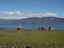
Upernavik Kujalleq Heliport (ICAO: BGKL) is a heliport in Upernavik Kujalleq, a village in the Upernavik Archipelago of Qaasuitsup municipality in northwestern Greenland. The heliport is considered a helistop, and is served by Air Greenland as part of a government contract.
Airlines and destinations
| Airlines | Destinations |
|---|---|
| Air Greenland (settlement flights) | Kangersuatsiaq, Upernavik[2] |
Air Greenland operates government contract flights to villages in the Upernavik area. These mostly cargo flights are not featured in the timetable,[2] although they can be pre-booked.[3] Departure times for these flights as specified during booking are by definition approximate, with the settlement service optimized on the fly depending on local demand for a given day.
References
- ↑ Greenland AIP for BGKL – Upernavik Kujalleq Heliport from Naviair
- 1 2 "Booking system". Air Greenland. Archived from the original on 22 April 2010. Retrieved 9 June 2010.
- ↑ Air Greenland, fare system rules Archived 2010-07-13 at the Wayback Machine.
This article is issued from
Wikipedia.
The text is licensed under Creative Commons - Attribution - Sharealike.
Additional terms may apply for the media files.