University District, Seattle
| University District | |
|---|---|
| Seattle Neighborhood | |
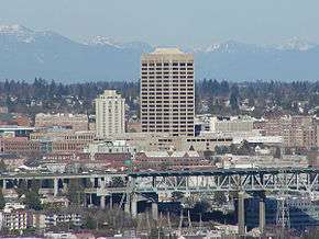 The U-District, looking northeast from Queen Anne. UW Tower is the tall building in the center, with the Hotel Deca (originally the Meany Hotel) to its left. The I-5 Ship Canal Bridge is in the foreground. | |
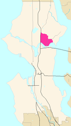 Map of the University District's location in Seattle |
The University District (commonly, the U District) is a district of neighborhoods in Seattle, Washington, so named because the main campus of the University of Washington (UW) is located there. The UW moved in two years after the area was annexed to Seattle, while much of the area was still clear cut forest or stump farmland. The district of neighborhoods grew with the university to become like a smaller version of urban American cities.[1]
Neighborhoods within the district include University Park (east from 15th to 25th Avenues N.E., north from N.E. 50th Street to N.E. Ravenna Boulevard), Greek Row (N.E. 45th to N.E. 50th Streets, 15th to 25th Avenues N.E.), University Heights (north of N.E. 45th Street and west of 15th Avenue N.E.) and the Brooklyn Addition (residential and Bohemian area west of 15th Avenue N.E. and south of N.E. 45th Street); as well as the Main, West and North campuses of the University of Washington.
Location
Like all Seattle districts, the boundaries of the University District are informal; by common usage, the University District is bounded on the west by Interstate 5; on the east by 25th Avenue NE; on the south by the Lake Washington Ship Canal; and on the north by NE Ravenna Boulevard. It also includes, east of these boundaries, a small district on the north shore of Union Bay, bounded on the north by NE 45th Street and on the east by 35th Avenue NE. This extension consists mainly of the "east campus" and extensive parking lots of the University.[2] Its main commercial street, University Way NE, is known throughout the city as "The Ave" in the "U District".
Some parts of the University District have had names of their own. For example, today "University Heights" mainly designates a former school used as a community center, University Heights Center for the Community; a 1905 map shows the name as applying specifically to the area bounded by what are now NE 45th Street to the south, NE 55th Street to the north, Brooklyn Avenue NE to the west, and 15th Avenue NE to the east.[3]
History
What is now the University District has been inhabited since the end of the last glacial period (c. 8,000 BCE—10,000 years ago). Prominent Native American Duwamish villages of the Lushootseed (Skagit-Nisqually) Coast Salish nations were on a then-larger Portage Bay at what is now called Brooklyn Avenue, and the other on a larger Union Bay, near the present UW power plant (which is across from the UW IMA building), around the north shores a mile farther than today, and shores east of what is now the Union Bay Natural Area. (See also adjacent Ravenna neighborhood.) The Duwamish,[5] ("People of the Inside") tribe had the prominent village of SWAH-tsoo-gweel ("portage") on then-adjacent Union Bay, and what is now Ravenna was their backyard before the arrival of European settlers.[6] Villages were diffuse. In spring, people dispersed from their winter villages of longhouses to camps, gathering in summer for salmon. Gaps in the forest were maintained to encourage game and food supplies. Such "prairies" (anthrogenic grasslands) were cultivated in what is now the University District.[7] They were connected by a well-travelled path along what is now the Lake Washington Ship Canal (1883, 1916).
Surveyors noted several large Douglas-firs and western red cedars (given that large trees were not unusual back then, these must have been especially large). The U. District was first surveyed in 1855, and its first white settlers arrived 12 years later. In 1890, that part of the neighborhood due west of the present UW campus was laid out as the Brooklyn Addition. One year later much of the land north of the Ship Canal, including Brooklyn, was annexed to Seattle. The UW moved from Downtown in 1893, and the first university building was built in 1895.
An 1894 report describes a train wreck just west of the current University District. Latona has now been cut off from the University by Interstate 5.
August 20, 1894. Wreck on [the] Seattle, Lake Shore and Eastern just west of Latone [now Latona Avenue]. Freight train from Gilman [now Snoqualmie] hit a cow. [Trainload was a] [m]ixer freight train, 10 co[a]l cars, logs and box cars. Train had slowed down at Brooklyn [Avenue] for cows. Engineer saw cows on a bank beyond Latona looking (?) one another[!]. One cow was tossed over [the] bank and hit the track just as [the] engine came by. [The] [e]ngine was raised off the track[,] and when it came down [the] wheels went off the rails. Engineer reversed but [it] was too late. [The] [c]oal tender shot ahead[,] tearing part of [the engine] car [(cab)] off and decapitating [the] fireman and killing [the] brakeman. Engineer and coal passer [were][8] unhurt. Steam and dust enveloped the derailed cars. Engineer ran to Fremont to telegraph to stop [the] evening passenger train[;] also [illegible] Engineer claimed train going 20 miles per hr.[9]
.jpg)
The name "Brooklyn" began to fade soon thereafter. Electric trolley tracks had been laid up Columbus Avenue (later 14th Avenue) in 1892, and the neighborhood soon began to be called "University Station" after the heated waiting house at the corner of what is now NE 42nd Street (1895). The name Brooklyn is not lost, however, for Brooklyn Avenue NE runs parallel to University Way, one block west.[1] North and west of the campus, within the University District, the University Heights—a name now little used—was named for its elementary school (1903–c.1988; since 1990 the University Heights Center for the Community Association, hosts numerous activities small and large from the University District Community Clean Up to the University District Farmer's Market.[10]
But for the trolley, in early decades of the U. District Downtown was a trek, a boat, and a horsecart ride away. Given these early transportation difficulties, the U. District was largely self-sufficient, with area businesses for people with ties to the University. Construction of family homes increased in the early 1900s, as did churches, theaters, stores, and a YMCA. The district's first bank and the first local public library opened in 1906, the modest library organized by local merchants.[11]
As a result of a contest held by the University Commercial Club in 1919, 14th Avenue (by then already known as "The Avenue" or "The Ave") was renamed University Way, and the neighborhood was renamed the University District (1919).[1] The neighborhood's north-south arterials are (from west to east) Roosevelt Way NE (southbound)), 11th Avenue NE (northbound), Brooklyn Avenue NE, University Way NE, and 15th Avenue NE. NE Pacific, 45th, and part of 50th streets are principal east-west arterials, NE Campus Parkway is a minor east-west arterial, running only west of the campus.[12]
Contemporary
The U District is characterized by the annual May U District Street Fair , the first of its kind in 1971,[14] started by local merchant and dedicated peace activist Andy Shiga in 1970,[15] and the University District Farmers Market,[16] Seattle's first (1993) and largest local farmers-only neighborhood market.[17] Andy Shiga (1919–1993) of Shiga's Imports and local attorney Calmar McCune (1911–1996) long supported development of the alternative character of the U District.[18] The ASUW Experimental College,[19] founded in the college culture of 1968 by a group of UW students seeking education in areas not found in the traditional university environment, is now the largest nonprofit student-run program of its kind. Open to all, it has contributed to the cultural ambience of the U District ever since.[20] The Blue Moon Tavern has become an unofficial cultural landmark, since 1934.[21] Big Time is Seattle's original brewpub (1988).[22] Opened in 1966 Dante's Bar&Nightclub is another popular venue and is known as "a U-District tradition." Six theatres (including the Neptune built in 1921,[23] the Varsity since 1940;[24] the Grand Illusion Cinema (founded in a former dental lab in 1968 by Randy Finley,[25] now owned and run by dedicated volunteers);[26] and the (locally-owned) Scarecrow Video, the largest video store on the West Coast[27] further characterize the neighborhood. The U District is second only to Capitol Hill as an epicenter for NoCat Free Wi-Fi with the global Seattle Wireless[28] project.
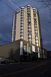
The neighborhood's skyline landmarks (other than the UW campus) are its tallest buildings: UW Tower (formerly Safeco Plaza) and the Meany Hotel (which became the Best Western University Tower and is now known as Hotel Deca). The former, originally headquarters of Safeco Corporation, is located at the corner of Brooklyn Avenue NE and NE 45th Street. It was built in 1973, and at 22 stories high is the city's tallest building outside Downtown. The latter is Art Deco (1931, restored). The architect Robert Reamer gave every room a corner window.[29] A jewel of the neighborhood is the formal Neo-classical Carnegie Library (1910) on Roosevelt Way at 50th Street.[11]
In recent decades, the University District has suffered commercial decline, due at least in significant part to the more competitive planning, capital investment, and popularity of the University Village shopping center east of the campus, and Northgate Mall about 1-1/2 miles (2-1/2 km) north beside I-5. From 2002 to 2004, the city and the neighborhood have made some steps countering this trend by giving the Ave a repaving facelift including the addition of benches, bus bulbs, and period lighting.[30] The addition of benches represented the reversal of a decades-long neighborhood trend away from providing free places to sit.
In the near future, the district will be served by two Link Light Rail stations: University of Washington Station near Husky Stadium is scheduled to open in 2016 as part of the University Link Extension;[31] and U District on Brooklyn Avenue near NE 45th Street to open in 2021 as part of the Northgate Link Extension. Light rail service will connect the U District to Capitol Hill, Downtown Seattle, Rainier Valley, and Sea-Tac Airport.[32]
The local year-round and seasonal homeless population, referred to as "Ave Rats", is well-known around Seattle. (See The Ave.)
Due to the size of the UW Greek system, fraternity and sorority members make up a sizeable portion of the local cafes' and bars' clientele, especially such establishments as Earl's and Fourno's, though well outnumbered by the Seattle campus student body of more than 39,250.[33] Other bars have a wider base of patrons, including the College Inn (built for the Alaska-Yukon Exposition in 1909)[34] and the Irish Emigrant. The University District is home to all of the UW's fraternity and sorority houses, most of them clustered along 17th Avenue NE between NE 45th and 50th Streets ("Frat Row" or "Greek Row").
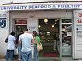 University Seafood and Poultry, founded 1945, one of the oldest surviving shops in the District.
 The Wannabee, one of the U. District's many independent coffeehouses (2006).
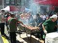 University District Street Fair, 2007.
See also
Notes
- 1 2 3 Dorpat
- ↑ "University District". Seattle City Clerk's Neighborhood Map Atlas. Office of the Seattle City Clerk. n.d., map.jpg 13 June 2002. Retrieved 2006-04-21. Check date values in:
|date=(help) - ↑ Baist's Real Estate Atlas Surveys of Seattle, Wash. 1905, G. Wm. Baist, Philadelphia, 1905, plates 17 & 18.
- ↑ Paul Dorpat, Seattle Neighborhoods: University District – Thumbnail History, HistoryLink, June 18, 2001. Accessed 4 December 2007.
- ↑ Also spelled Dkhw'Duw'Absh, pronounced [dxʷdɐwʔabʃ].
- ↑ Dailey, 26, ref. 2, 8
- ↑ Similar remarks could be made about Belltown, South Lake Union, along the shores of Lake Washington (the present day route of Sand Point Way NE), and most likely Alki, Georgetown, and other locations in what is now Seattle. Sources: Anderson & Green; Dorpat; "Southern Coast Salish Territories" map Archived 2006-06-18 at the Wayback Machine. in University of Washington Digital Collection. See also Duwamish tribe Lushootseed Coast Salish
- ↑ "[illegible]"—likely "The engineer and coal passer were unhurt." Relatively.
- ↑ (1) The mentioned streets at that time were rural, more tracks or plat lines than avenues. The run to Fremont Station was more than a mile (about 2 km). A small freight depot remains today at the foot of Stone Way N. Railroading before labor rights and worker safety was appallingly dangerous.
(2) Photographer unknown (20 August 1894) [photo]. "Train wreck in University District, August 20, 1894" (description of photo). University of Washington Libraries. Special Collections Division. Archived from the original on 15 December 2012. Retrieved 2006-07-21. Quoted text is from the verso of the original paper print, verbatim but for grammar in square brackets. - ↑ Long; Eskenazi. Neighborhoods within some districts in Seattle are more or less no longer in common usage. See also Seattle neighborhoods#Public library branches, public schools, and public parks and Seattle neighborhoods#Informal districts.
- 1 2 Burrows
- ↑ "Street Classification Maps". Seattle Department of Transportation. 2005. Archived from the original on 2006-06-14. Retrieved 2006-04-21.
High-Resolution Version Archived 2015-09-24 at the Wayback Machine., PDF format, 16.1 MB
Medium-Resolution Version Archived 2016-03-02 at the Wayback Machine., PDF format, 1.45 MB 12 January 2004.
Low-Resolution Version Archived 2006-06-22 at the Wayback Machine., PDF format, 825 KB 12 January 2004.
"Planned Arterials Map Legend Definitions" Archived 2006-01-17 at the Wayback Machine., PDF format. 12 January 2004.
The high resolution version is good for printing, 11 x 17. The low and medium resolution versions are good for quicker online viewing. [Source: "Street Classification Maps, Note on Accessing These PDF Files" Archived 2006-06-14 at the Wayback Machine.] - ↑ Walt Crowley, Blue Moon Tavern, An Unofficial Cultural Landmark, HistoryLink.org Essay 1001, April 1, 1999.
- ↑ "U District Street Fair". Greater University Chamber of Commerce. 2006. Retrieved 2006-04-21. External link in
|publisher=(help) - ↑ Crowley (revised 2004 and 9 May 2001, Essay 1126)
- ↑ "Archived copy". Archived from the original on May 9, 2005. Retrieved 2006-04-21.
- ↑ The U- District Farmers Market is Seattle's only Farmers Market that is open year-round (aside from Pike Place Market). "University District Farmers Market". Neighborhood Farmers Market Alliance. 2006. Archived from the original on 2006-01-11. Retrieved 2006-04-21.
- ↑ Crowley (19 March 2001)
- ↑ Catalog – Experimental College. Depts.washington.edu. Retrieved on 2013-08-25.
- ↑ "About the Experimental College". ASUW Experimental College (Associated Students of the University of Washington). 2002. Archived from the original on 2006-02-08. Retrieved 2006-04-21.
- ↑ Crowley (1 April 1999)
- ↑ Samson
- ↑ "Neptune Theatre". Landmark Theatres. n.d. Archived from the original on January 2, 2010. Retrieved 2006-04-21.
- ↑ "Varsity Theatre". Seattle Parks and Recreation. n.d. Archived from the original on 2006-04-22. Retrieved 2006-04-21.
- ↑ Doug Merlino, Finley, Randy (b. 1942), HistoryLink, March 22, 2005. Accessed 1 December 2006.
- ↑ Moe
- ↑ D'Oh Inc.
- ↑ FrontPage Archived 2006-04-23 at the Wayback Machine.. SeattleWireless (2013-01-21). Retrieved on 2013-08-25.
- ↑ University District Arts and Heritage Committee (Part 2 of 2, North Side)
- ↑ Marmor; Dorpat; Kim
- ↑ "University of Washington Station". Sound Transit. Archived from the original on June 26, 2015. Retrieved June 24, 2015.
- ↑ "U District Station". Sound Transit. Retrieved June 24, 2015.
- ↑ 3,600 instructional faculty, 27,600 faculty and staff, 39,251 student enrollment on Seattle campus (Autumn 2005), 26,444 extension enrollment (non-graded programs). "Quick Facts". UW Home > UWIN > About the UW > UW Profile. University of Washington. 18 April 2005. Archived from the original on 12 April 2006. Retrieved 2006-04-21.
- ↑ University District Arts and Heritage Committee (Part 1 of 2, South Side)
References
- "About the Seattle City Clerk's On-line Information Services". Information Services. Seattle City Clerk's Office. 2006-04-30. Retrieved 2006-05-21.
See heading, "Note about limitations of these data". - Anderson, Ross; Green, Sara Jean (2001-05-27). "A culture slips away". The Seattle Times. p. 1. Archived from the original on 2006-05-07. Retrieved 2006-04-21.
and Ibid. "'The settlers saw trees, endless trees. The natives saw the spaces between the trees.'". Seattle History: 150 Years: Seattle By and By. The Seattle Times. p. 2. Archived from the original on 2006-05-18. Retrieved 2006-04-21. - "About the Experimental College". ASUW Experimental College. Departments, University of Washington. 2002. Archived from the original on 2006-02-08. Retrieved 2006-04-21.
- Burrows, Alyssa (19 December 2002). "University Branch, The Seattle Public Library". HistoryLink.org Essay 4051. Retrieved 2006-04-21.
- Eskenazi, Stuart (93 April 2006). "New lease on hold for U Heights Center". Local News. The Seattle Times. Retrieved 2006-07-21. Check date values in:
|date=(help) - Castro, Hector (14 February 2006). "6 arrests tied to E. African gang: Group had been active in UW area, authorities say". Seattle Post-Intelligencer. Retrieved 21 April 2006.
- Castro, Hector (13 February 2006). "Gang arrests made: Members sold drugs and threatened UW students, feds say". Seattle Post-Intelligencer. Retrieved 2006-04-21.
- Castro, Hector (13 December 2005). "Seattle takes step on 'alcohol-impact area': City Council votes to ask state to expand zone". Seattle Post-Intelligencer. Retrieved 2006-04-21.
- Cline, Scott, City Archivist (n.d., ~2006). "Department of Community Development (1600)". A Guide to the Archives of the City of Seattle. Office of the Seattle City Clerk. Retrieved 2006-04-21. Check date values in:
|date=(help) - Crowley, Walt (1 April 1999). "Blue Moon Tavern, An Unofficial Cultural Landmark". Retrieved 2006-04-21. Crowley here is citing his own Forever Blue Moon, The Story of Seattle's Most (In)Famous Tavern, Seattle: Blue Moon, 1992.
- Crowley, Walt (19 March 2001). "McCune, Calmar (1911–1996), unofficial Mayor of the University District". HistoryLink.org Essay 3113. Retrieved 2006-04-21.
- Crowley, Walt (9 May 2001) [11 May 1999]. "University District (Seattle) Street Fair is first held May 23 and 24, 1970". HistoryLink Essay 1126. Retrieved 2006-04-21.
- Dailey, Tom (n.d.). "Duwamish-Seattle". "Coast Salish Villages of Puget Sound". Retrieved 2006-04-21. External link in
|work=(help)
Page links to Village Descriptions Duwamish-Seattle section. - D'Oh Inc (2006). "About us". Scarecrow. Archived from the original on 2006-04-11. Retrieved 2006-04-21.
- Dorpat, Paul (18 June 2001, updated May 2002). "Seattle Neighborhoods: University District – Thumbnail History". HistoryLink.org Essay 3380. Retrieved 2006-04-21. Check date values in:
|date=(help) - Griffen, Tom; Marmor, John (March 2002). "Husky Stadium". A place apart. Columns, The University of Washington Alumni Association. Retrieved 2006-06-21.
- Kim, Gina (10 February 2001). "Empty storefronts litter 'the Ave'". Business & Technology. The Daily of the University of Washington. Retrieved 2006-07-14.
- Moe, John (2 May 2006). "New Google Features / Isernio Sausage / Grand Illusion Cinema". The Works. KUOW-FM. Archived from the original (link to RealAudio, MP3) on 28 September 2007. Retrieved 2006-05-21.
John Moe interview with Guerren Marter, Grand Illusion Cinema manager. - "HISTORY @ UBNA". Center for Urban Horticulture, Departments of the University of Washington. (n.d., 1999 per "Montlake Landfill Information Summary, January 1999" on page). Archived from the original on 2006-05-17. Retrieved 2006-04-21. Check date values in:
|date=(help) - JasonMcArthur, mattw, [sic] & staff (19 April 2006, revised). "FrontPage". SeattleWireless. Archived from the original on 23 April 2006. Retrieved 2006-04-21. Check date values in:
|date=(help) - Kline, Sally (8 April 1999). "Present inconveniences for a promising future: UW athletes are learning to deal with the inconvenience of Hec-Ed renovation". The Daily of the University of Washington. Archived from the original on 23 June 2006. Retrieved 2006-06-21.
- Long, Priscilla (18 June 2001). "University Heights Elementary School opens in the University District in September 1903". HistoryLink.org Essay 3381. Retrieved 2006-07-21.
- Marmor, Jon (December 1995). "Once Seattle's Second Main Street, the Ave. Has Fallen on Hard Times. Can the UW and Local Community Save What's Left?". "The Fall (and Rise?) of the 'Ave.'". Columns. Retrieved 2006-04-21.
Alumni magazine. - "Neptune Theatre". Landmark Theatres. n.d. Archived from the original on 2010-01-02. Retrieved 2006-04-21.
- "NoCat.net". Retrieved 2006-04-21.
"Seattle Wireless: One of the first community wireless networks, and probably one of the largest." - Publication Services & UW Facility Services (Revised July 1996). The University of Washington Campus & Vicinity (map). Seattle: University of Washington. Check date values in:
|year=(help) - "Quick Facts". UW Home > UWIN > About the UW > UW Profile. University of Washington. 18 April 2005. Archived from the original on 12 April 2006. Retrieved 2006-04-21.
- Samson, Karl. "Big Time Brewery and Alehouse". Frommers. Retrieved 2006-04-21.
Previously retrieved 15 November 2005.
Links to "Seattle's Original Brewpub". Selection from Samson, Karl (2006). Frommer's Seattle 2006. Wiley. ISBN 0-7645-9587-3.
[Title incremented annually each January]. - "N. HISTORIC/CULTURAL". Section III – Historic & Cultural, Master Plan Seattle Campus Final EIS (PDF). Seattle: University of Washington. 12 September 2001. p. 210. Archived from the original (PDF) on 9 September 2006. Retrieved 2006-06-21.
Master Plan Seattle Campus Final EIS of Campus Master Plan - Shenk, Carol; Pollack, Laurie; Dornfeld, Ernie; Frantilla, Anne; Neman, Chris (26 June 2002, maps.jpg c. 15 June 2002). "About neighborhood maps". Seattle City Clerk's Office Neighborhood Map Atlas. Information Services, Seattle City Clerk's Office. Retrieved 2006-04-21. Check date values in:
|date=(help)
Sources for this atlas and the neighborhood names used in it include a 1980 neighborhood map produced by the Department of Community Development (relocated to the Department of Neighborhoods and other agencies), Seattle Public Library indexes, a 1984–1986 Neighborhood Profiles feature series in the Seattle Post-Intelligencer, numerous parks, land use and transportation planning studies, and records in the Seattle Municipal Archives.
[Maps "NN-1120S", "NN-1130S", "NN-1140S".Jpg [sic] dated 13 June 2002; "NN-1030S", "NN-1040S".jpg dated 17 June 2002.] - "Southern Coast Salish Territories". "Maps". University of Washington Libraries, Digital Collections. Archived from the original on 2006-06-18. Retrieved 2006-04-21. External link in
|work=(help)
"Maps" is part of "American Indians of the Pacific Northwest Collection", at Libraries Home > Subject > History > Tm > Pacific Northwest History. - "Street Classification Maps". Seattle Department of Transportation. 2005. Archived from the original on 2006-06-14. Retrieved 2006-04-21.
High-Resolution Version, PDF format, 16.1 MB
Medium-Resolution Version, PDF format, 1.45 MB 12 January 2004.
Low-Resolution Version, PDF format, 825 KB 12 January 2004.
"Planned Arterials Map Legend Definitions", PDF format. 12 January 2004.
The high resolution version is good for printing, 11 x 17. The low and medium resolution versions are good for quicker online viewing. [Source: "Street Classification Maps, Note on Accessing These PDF Files"] - "U District Street Fair". Greater University Chamber of Commerce. 2006. Retrieved 21 April 2006. External link in
|publisher=(help) - "University District". Seattle City Clerk's Neighborhood Map Atlas. n.d., map.jpg 13 June 2002. Retrieved 2006-04-21. Check date values in:
|date=(help) - University District Arts and Heritage Committee (14 August 2001). "Public Art & Culture Walking Tour Map, Part 1 of 2, South Side" (PDF). City of Seattle Arts. Archived from the original (PDF) on September 25, 2007. Retrieved 2006-04-21.
- University District Arts and Heritage Committee (14 August 2001). "Public Art & Culture Walking Tour Map, Part 2 of 2, North Side" (PDF). City of Seattle Arts. Archived from the original (PDF) on 2006-01-08. Retrieved 2006-04-21.
- "University District Farmers Market". Neighborhood Farmers Market Alliance. 2006. Archived from the original on 2006-01-11. Retrieved 2006-04-21.
- University of Washington Computing and Communications, Facilities Services (2005, modified 18 May 2006). "Northeast Campus Map". UW Home > UWIN > About the UW > Campus Maps. University of Washington. Retrieved 2006-04-21. Check date values in:
|date=(help)
(2) UW Publication Services & UW Facility Services (Revised July 1996)
(3) University of Washington Publication Services (Revised September 1991) - University of Washington Publication Services (Revised September 1991). The University of Washington Campus & Vicinity (map). Seattle: University of Washington. Check date values in:
|year=(help)
Compiled, designed, drafted in cooperation between Physical Plant and the Department of Geography, August 1971, revised Sherman (August 1991). - "Varsity Theatre". Landmark Theatres. n.d. Archived from the original on 2006-04-22. Retrieved 2006-04-21.
External links
| Wikivoyage has a travel guide for Seattle/University District. |
| Wikimedia Commons has media related to University District, Seattle, Washington. |
- Seattle City Clerk's Neighborhood Map Atlas — University District
- University Chamber of Commerce website
- Seattle Photograph Collection, University District – University of Washington Digital Collection
- University Village website
Coordinates: 47°39′18″N 122°18′12″W / 47.65500°N 122.30333°W