Union Hill, Alabama
| Union Hill, Alabama | |
|---|---|
| Unincorporated community | |
 Union Hill, Alabama Location in Alabama. | |
| Coordinates: 34°28′25″N 86°37′19″W / 34.47361°N 86.62194°W | |
| Country | United States |
| State | Alabama |
| County | Morgan |
| Elevation | 1,270 ft (387 m) |
| Time zone | UTC-6 (Central (CST)) |
| • Summer (DST) | UTC-5 (CDT) |
| Area code(s) | 256 |
Union Hill, also known as Wolff, is an unincorporated community in the eastern portion of Morgan County, Alabama, United States.[1] It is one of the highest points on Brindlee Mountain, part of the Appalachian Mountain Range. The area consists of Union Hill School (a K-8 school), Union Hill Grocery and New Canaan Baptist Church. The broadcast tower for radio station WRSA Lite 96.9 is also located in Union Hill. A post office operated under the name Wolff from 1899 to 1905.[2]
Notes
- ↑ "Union Hill, Alabama". Geographic Names Information System. United States Geological Survey.
- ↑ "Morgan County". Jim Forte Postal History. Retrieved 29 December 2014.
Municipalities and communities of Morgan County, Alabama, United States | ||
|---|---|---|
| Cities | 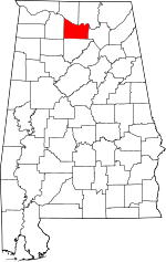 | |
| Towns | ||
| Unincorporated communities | ||
| Ghost town | ||
| Footnotes | ‡This populated place also has portions in an adjacent county or counties | |
This article is issued from
Wikipedia.
The text is licensed under Creative Commons - Attribution - Sharealike.
Additional terms may apply for the media files.