Umapine, Oregon

Umapine (pronounced U-mah-pine) is a census-designated place and unincorporated community in Umatilla County, Oregon, United States, two miles from the Oregon-Washington border. The traditional boundary covers a wide area.[1] It has a population of 315 people as of 2010. The community is part of the Pendleton–Hermiston Micropolitan Statistical Area. The current economy is supported by agriculture, including wheat and hay farms, apple orchards, and an increasing number of vineyards. The main establishments in the town are Tate's Umapine Market, The Umapine Creamery and the Waterhole Tavern.[2]

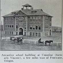
For several decades the town had a school that served kindergarten through twelfth grade and whose mascot was the Umapine Chiefs. The enrollment at the school averaged 100 students. The school closed and incorporated with nearby Ferndale School District in 1984, which later incorporated with Milton-Freewater Unified School District in the early 1990s. In the early 1990s, the 1911 school building was sold to a local artist who established a fine art bronze foundry, Old School Bronze (formerly Northwest Art Casting).[2] After the death of the owner the school has since fell into disuse and is currently on the market for sale. It is a three story brick structure with incredible views on 5 acres.
Per recent news paper articles, In 2013 Umapine became notorious for a violent murder. After this event the town rallied and has now become one of the safest communities in Umatilla County. Over 90% of the population subscribe to the internal communication system. At the direction of local law enforcement and banks several meth houses were removed. Several vacant homes were purchased and rehabilitated. Home values have risen significantly each year.
It is home to 2 highly rated restaurants, Tate's Mercantile and the Waterhole, and the Umapine Creamery. Tate's is housed in one of the original post office and creamery's from 1900s. The Waterhole has existed in various forms to the 1940's. Umapine Creamery is a newer addition. The family run business and dairy sells cheese at premiere locations throughout the Walla Walla Valley. It is a popular stop on routes favored by motorcycle and bicycle groups.

The community holds regular community "Spring Cleans" and Community Yard Sales. Alternating between the two every two years. The community is now home to several artisans as well as century-old cattle operations. The town of 300 is home to several employers.[3] The community reacts quickly to criminal activity coming together to offer rewards. .[4]
History_________________________________________________
It was established as a railroad stop on the Walla Walla Valley Railway[5] with an active lumber yard and large population of dairies in the early 1900s. The railway was abandoned in 1942 and became the Umapine Highway[6]. Umapine was originally named Vincent, Oregon, until the community acted to get its own post office.[7] Since there was already a post office by that same name in Wallowa County, the place was renamed for a prominent Indian chief who had once lived in the area, Chief Umapine, who was either of the Cayuse or Umatilla people.[7] The post office was established in June 1916.[7] After several fires in the post office building, Umapine post office, ZIP code 97881, was closed in December 1966. Umapine now has a Milton-Freewater mailing address, whose ZIP code is 97862.

1936 State Line earthquake was centered on Umapine. Near Umapine there were cracks in the ground up to 6 inches (15 cm) wide that had water flowing out of them, demonstrating soil liquefaction. Some cracks were 8 feet (2.4 m) deep.Observers in Walla Walla noted rumbling noises immediately preceding the first shocks. At one point the ground dropped by 2.4 metres (7.9 ft). About 70% of headstones at a nearby cemetery were found to have been rotated clockwise.[8]
References
- ↑ "Umapine, Oregon :: Boundary Map of Umapine, Oregon". www.maptechnica.com. Retrieved 2018-07-20.
- 1 2 Seven, Richard (January 23, 2005). "The Work of Art: From Mold to Molten Pour to Patina, Ideas Take Shape". The Seattle Times. Retrieved 2008-09-14.
- ↑ "Umapine? Doing Fine". Union-Bulletin.
- ↑ [The community reacts offering rewards for information on criminal activity. "Umapine rallies for return of stolen items"] Check
|url=value (help). Union-Bulletin. - ↑ Walla Walla Valley Railway: Memories from the General Manager. Accessed September 13, 2008
- ↑ "Abandoned Rails: The Umapine Branch". www.abandonedrails.com. Retrieved 2018-07-20.
- 1 2 3 McArthur, Lewis A.; Lewis L. McArthur (2003) [1928]. Oregon Geographic Names (Seventh ed.). Portland, Oregon: Oregon Historical Society Press. pp. 979–980. ISBN 0-87595-277-1.
- ↑ "1936 State Line earthquake", Wikipedia, 2018-07-15, retrieved 2018-07-20
External links
- U.S. Geological Survey Geographic Names Information System: Umapine, Oregon
- Portrait of Chief Umapine by Lee Moorhouse, from the Yakima Valley Regional Library
Coordinates: 45°58′35″N 118°29′47″W / 45.9765234°N 118.4963620°W
Municipalities and communities of Umatilla County, Oregon, United States | ||
|---|---|---|
| Cities | 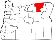 | |
| CDPs | ||
| Other unincorporated communities | ||
| Indian reservation | ||
| Ghost towns | ||