Ubobo
| Ubobo Queensland | |
|---|---|
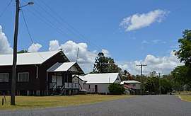 Railway Terrace, 2017. From the left the buildings shown are the Ubobo Memorial Hall, the QCWA rest rooms, the former Station Mistress' house and a private dwelling | |
 Ubobo | |
| Coordinates | 24°25′S 151°19′E / 24.417°S 151.317°ECoordinates: 24°25′S 151°19′E / 24.417°S 151.317°E |
| Postcode(s) | 4680 |
| Location | |
| LGA(s) | Gladstone Region |
| State electorate(s) | Callide |
| Federal Division(s) | Flynn |
Ubobo is located south of Gladstone and Calliope along Highway 69 in Central Queensland, Australia. It is one of four small townships within the locality of Boyne Valley along with Nagoorin, Builyan, and Many Peaks. It is part of the Gladstone Region.
Ubobo is a small town found in the middle of the Boyne Valley, which is mostly made up of family farms that have been passed on to the next generation over the years. The town is made up of the Ubobo General Store, the local garage, two small churches, a small historical centre, a well used QCWA, the Ubobo Discovery Center that has been restored by the community, as well as Ubobo State School. Ubobo State School is one of three schools in the Boyne Valley.
Education
Ubobo State School opened on 23 March, 1927. [1] The school caters to students from Prep - Year 6 and at the end of 2016 had 15 enrolled students. [2]
Heritage listings
Ubobo has a number of heritage-listed sites, including:
- Gladstone-Monto Road: Soldier Settler House[3]
References
- ↑ "Opening and closing dates of schools in Queensland". Education Queensland. 13 August 2013. Retrieved 30 January 2017.
- ↑ "Ubobo State School newsletter" (PDF). Education Queensland. Retrieved 30 January 2017.
- ↑ "Soldier Settler House (entry 602229)". Queensland Heritage Register. Queensland Heritage Council. Retrieved 8 July 2013.
External links
![]()
- The Boyne Valley, Queensland, Australia
- Map of The Boyne Valley
- University of Queensland: Queensland Places: Gladstone Localities
- Ubobo State School website
- List of articles about Ubobo State School on Trove