U.S. Route 6 in California
| ||||
|---|---|---|---|---|
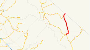 US 6 highlighted in red | ||||
| Route information | ||||
| Defined by Streets and Highways Code § 306 | ||||
| Maintained by Caltrans | ||||
| Length | 40.51 mi[1] (65.19 km) | |||
| Existed | 1936[2]–present | |||
| Major junctions | ||||
| South end |
| |||
|
| ||||
| North end |
| |||
| Location | ||||
| Counties | Inyo, Mono | |||
| Highway system | ||||
| ||||
.svg.png)
U.S. Route 6 (US 6) is a transcontinental highway from the U.S. state of California to Massachusetts. In California, the highway lies in the eastern portion of the state from Bishop in the Owens Valley north to the Nevada state line in Mineral County. Prior to a 1964 Highway renumbering project US 6 extended to the Pacific Ocean in Long Beach, California, as part of the historic auto trail named the Grand Army of the Republic Highway.[4]
Route description
Starting in Inyo County, US 6 begins its route at Bishop at a junction with US 395 near the Bishop Paiute-Shoshone Indian Colony. After leaving Inyo County and entering Mono County, the highway proceeds due north to the town of Benton, and makes a junction with SR 120. The highway then begins ascending the lower foothills of the White Mountains, towards Montgomery Pass in Nevada. The highway reaches the state line before cresting the pass. While still in California, the highway passes Boundary Peak, the highest point in Nevada.[5]
US 6 is part of the California Freeway and Expressway System,[6] and is part of the National Highway System,[7] a network of highways that are considered essential to the country's economy, defense, and mobility by the Federal Highway Administration.[8] US 6 is eligible to be included in the State Scenic Highway System,[9] but it is not officially designated as a scenic highway by the California Department of Transportation.[10]
History
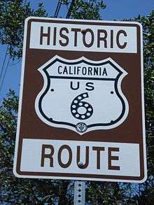
The California portion of US 6 was originally commissioned in 1937 as an extension of the highway from Greeley, Colorado as part of the historic Grand Army of the Republic Highway auto trail.[11]
Grand Army of the Republic Highway
US 6 was later extended further south through the Mojave Desert and Los Angeles to Long Beach in Southern California.[4] It traveled along with what is now US 395, SR 14 (Sierra Highway), I-5, I-110 / SR 110, and SR 1. When the Four Level Interchange was constructed, US 6 was the original number for SR 110 at this interchange.
It formerly ran from Long Beach west to San Pedro and continued north on Figueroa Street, briefly concurrent with US 66 in Los Angeles before turning northwest and co-signing with US 99 on San Fernando Road. US 66 continued north on the Pasadena Freeway before also being decommissioned in 1964, leading to the Harbor and Pasadena freeways being redesignated to SR 11, which ran from Gaffey Street in San Pedro to Colorado Boulevard in Pasadena. In 1981, the Harbor Freeway between Gaffey Street and Interstate 10 became Interstate 110, replacing the SR 11 designation. The northern segment of SR 11 continuing to Glenarm Street became SR 110, which continues briefly as the Harbor Freeway before becoming the Pasadena Freeway north of the Four Level Interchange with US 101.
Renumbering
In 1964, all of the route of US 6 in California south of Bishop lost official status with its US 6 signs removed. The highway was truncated to Bishop as part of a 1964 highway renumbering project.[12]
Major intersections
Except where prefixed with a letter, postmiles were measured on the road as it was in 1964, based on the alignment that existed at the time, and do not necessarily reflect current mileage. R reflects a realignment in the route since then, M indicates a second realignment, L refers an overlap due to a correction or change, and T indicates postmiles classified as temporary (for a full list of prefixes, see the list of postmile definitions).[1] Segments that remain unconstructed or have been relinquished to local control may be omitted. The numbers reset at county lines; the start and end postmiles in each county are given in the county column.
| County | Location | Postmile [1][13][14] | Destinations | Notes | |
|---|---|---|---|---|---|
| Inyo INY R0.00-8.35 | Bishop | R0.00 | South end of US 6; former US 6 south | ||
| Mono MNO 0.00-32.29 | Benton | 25.72 | |||
| | 27.30 | Agricultural Inspection Station (southbound only) | |||
| | 32.29 | Continuation into Nevada | |||
| 1.000 mi = 1.609 km; 1.000 km = 0.621 mi | |||||
See also

- Midland Trail
- Category: Historic trails and roads in California
References
- 1 2 3 California Department of Transportation. "State Truck Route List". Sacramento: California Department of Transportation. Archived from the original (XLS file) on June 30, 2015. Retrieved June 30, 2015.
- ↑ Daniel P. Faigin. "California Highways Routes 1 through 8". Retrieved 2007-12-19.
- ↑ Caltrans - Route and Direction Archived 2008-01-19 at the Wayback Machine., accessed December 2007
- 1 2 Michael Ballard. "Virtual Tour of old US 6". Retrieved 2013-02-20.
- ↑ Nevada Road and Recreation Atlas (Map) (2003 ed.). 1:250000. Benchmark Maps. 2003. p. 70. § B2. ISBN 0-929591-81-X.
- ↑ California State Legislature. "Section 250–257". Streets and Highways Code. Sacramento: California State Legislature. Retrieved June 9, 2017.
- ↑ Federal Highway Administration (March 25, 2015). National Highway System: California (North) (PDF) (Map). Scale not given. Washington, DC: Federal Highway Administration. Retrieved October 20, 2017.
- ↑ Natzke, Stefan; Neathery, Mike & Adderly, Kevin (June 20, 2012). "What is the National Highway System?". National Highway System. Washington, DC: Federal Highway Administration. Retrieved July 1, 2012.
- ↑ California State Legislature. "Section 260–284". Streets and Highways Code. Sacramento: California State Legislature. Retrieved June 9, 2017.
- ↑ California Department of Transportation (September 7, 2011). "Officially Designated State Scenic Highways and Historic Parkways". Sacramento: California Department of Transportation. Retrieved October 20, 2017.
- ↑ Richard F. Weingroff. "U.S. 6- The Grand Army of the Republic Highway". United States Department of Transportation - Federal Highway Administration. Retrieved 2007-12-19.
- ↑ Dale Sanderson. "End of US highway 6". Archived from the original on 2008-02-06. Retrieved 2007-12-19.
- ↑ California Department of Transportation (July 2007). "Log of Bridges on State Highways". Sacramento: California Department of Transportation.
- ↑ California Department of Transportation, All Traffic Volumes on CSHS, 2005 and 2006
External links
| Wikimedia Commons has media related to U.S. Route 6 in California. |
Route map:
- AARoads - U.S. Route 6 in California
- California Highways: U.S. Route 6
- Caltrans: U.S. Route 6 highway conditions
- Socalregion.com: Virtual Tour of U.S. Route 6 in California and western Nevada
| Previous state: Terminus |
California | Next state: Nevada |