Two-Mile Borris
| Two-Mile Borris Buiríos Léith | |
|---|---|
| Village | |
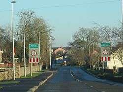 Entrance to the village | |
 Two-Mile Borris Location in Ireland | |
| Coordinates: 52°40′22″N 7°42′45″W / 52.67290°N 7.71262°WCoordinates: 52°40′22″N 7°42′45″W / 52.67290°N 7.71262°W | |
| Country | Ireland |
| Province | Munster |
| County | Tipperary |
| Elevation | 120 m (390 ft) |
| Population (2006) | |
| • Urban | 550 |
| Time zone | UTC+0 (WET) |
| • Summer (DST) | UTC-1 (IST (WEST)) |
| Irish Grid Reference | S194580 |
Two-Mile Borris (also written Twomileborris) is a small village in County Tipperary, Ireland. The village is located on the L4202 road at the junction with the Ballyduff Road, close to the N75 and 7.5 km (4.7 mi) from Thurles town centre. It is also situated 1.5 km from junction 5 of the M8 motorway. Its population was 502 at the 2006 census.[1] It is situated in the townland of Borris, Twomileborris which is part of the civil parish of Twomileborris in the ancient barony of Eliogarty.[2]
History
In the 1830s, the village was the property of Hugh Nugent O'Reilly.[3]
History of the placename
The name Borris is generally believed to have come from the Norman word for a borough, district or stronghold. The Irish name Buiríos Léith was historically anglicised as Borrisleigh or Borris Leigh.[4] The use of Leigh in the placename would seem to be related to the monastic settlement of Liathmore-Mochoemóg in Leigh, about a mile and a half to the north-east of the village. Those who prefer the Irish name of Buirgheas Dhá Mhíle say that the name refers to King Mile, ancestor of Niall of the Nine Hostages and numerous Irish Kings and heroes.
Amenities and facilities
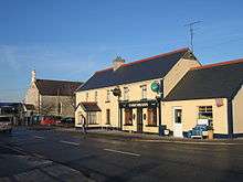
It has a primary school, Catholic church, two pubs and two shops. There are a number of housing estates. The townland makes up an area of 23.91 square kilometres (Ref:Image:IMG 2MileSign4742w.jpg), most of which is given over to agricultural use. The village is located right at the edge of the Golden Vale and the Bog of Allen and so the quality of the land varies around the area, with most of the best farming land located to the west of the village. Parts of the land to the east are too boggy to be used, even for extracting turf. The village proper is bounded on the west by the Black River, a tributary of River Drish, which goes on to join River Suir. The approach to the village is dominated by a Norman tower-house.
In June 2011 planning permission was given by An Bord Pleanála for a casino, hotel with 500 rooms and a racetrack, known as the Tipperary Venue.[5]
See also
Notes
Putting the barony in its historico-geographical context.
- Barony - an old administrative division. Eliogarty - one of 14 baronies in the old county, between Ikerrin to the north (whose chief town is Roscrea), Kilnamanagh Upper to the west (whose chief town is Borrisoleigh) and Middle Third to the south (whose chief town is Cashel).
References
- ↑ Irish census 2006 Archived 2011-07-17 at the Wayback Machine.
- ↑ Placenames database of Ireland - Twomileborris civil parish
- ↑ Samuel Lewis, Topographical Dictionary of Ireland, 1837
- ↑ Placenames Database of Ireland (see archival records)
- ↑ "Two-Mile Borris casino given go ahead". RTÉ News and Current Affairs. 13 June 2011. Retrieved 13 June 2011.
External links
| Wikimedia Commons has media related to Two-Mile Borris. |
Places in County Tipperary | ||
|---|---|---|
| Towns | 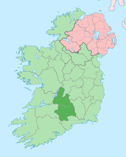 | |
| Villages |
| |
| Baronies | ||
| ||