Kilsheelan
| Kilsheelan Cill Síoláin | |
|---|---|
| Village | |
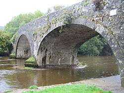 Kilsheelan Bridge, built c.1820[2] | |
 Kilsheelan Location in Ireland | |
| Coordinates: 52°21′41″N 7°34′49″W / 52.361481°N 7.580344°WCoordinates: 52°21′41″N 7°34′49″W / 52.361481°N 7.580344°W | |
| Country |
|
| Province | Munster |
| County | County Tipperary |
| Time zone | UTC+0 (WET) |
| • Summer (DST) | UTC-1 (IST (WEST)) |
Kilsheelan (Irish: Cill Síoláin) is a small village in County Tipperary, Ireland.[3] It is also a civil parish in the barony of Iffa and Offa East. It is one half of the Roman Catholic parish of Kilsheelan & Kilcash in the Roman Catholic Diocese of Waterford and Lismore. It is situated on the north bank of the River Suir, 8.5 km east of Clonmel and 11.8 km west of Carrick-on-Suir. It has a population of around 550 to 650 people. Kilsheelan has won Tidy Towns twice in 1975 and 1979.[4] Its GAA club is Kilsheelan-Kilcash.
History
Excavations in 2006 at a residential development revealed evidence of settlement at the village dating back to early neolithic period. Finds included pottery fragments, stone blades and seeds.[5]
The name of the village in Irish is Cill Síoláin, meaning church of Síolán/Sillan.[6] Síolán is thought to be an early Irish saint[7] probably Sillan, abbot of Bangor Abbey in Bangor, County Down.[5][8] Síolán can translate to either "seed-basket"[9][10] or "cullender/sieve".[11]
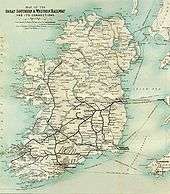
In 1853 Kilsheelan railway station was opened by the Waterford, Limerick and Western Railway, later taken over by the Great Southern & Western Railway, it being one of many small provincial stations to serve settlements along the route. It was closed in 1963 to passengers and then to goods in 1976. Until 1984 the station served as a block post, at which point sidings and loop were removed. The original Great Southern & Western signal box remains extant, being used to house operator of the adjacent manual level crossing on the R706 road.[12]
Historical population
Population shown accounts for the entire parish of Kilsheelan starting in 1831.[13][14]
| Year | Population | Change |
|---|---|---|
| 1831[13] | 1,570 | – |
| 1841[14] | 1,576 | 0.38 |
| 1851 | 1,491 | −5.39 |
| 1861 | 1,130 | −24.21 |
| 1871 | 941 | −16.73% |
Geography
Townlands
- Ballinvoher
- Ballyboe
- Ballydine
- Ballyglasheen
- Ballyglasheen
- Ballynaraha
- Ballynevin
- Butlerstown
- Clashanisky
- Cloghcarrigeen East
- Cloghcarrigeen West
- Clonwalsh
- Eustaceland
- Gammonsfield
- Gortbrack
- Greensland
- Kilsheelan
- Knockanclash
- Lisbalting
- Lisnatubbrid
- Mauganstown
- Minorstown
- Mullenaranky
- Poulakerry
- Priorstown
- Seskin
- Skehanagh
- Temple-Etney
Facilities
It has 4 pubs, a post office and a Peugeot car dealership.
In 2004, Marilyn Manson married the burlesque performer Dita Von Teese in a ceremony at Castle Gurteen de la Poer in Kilsheelan,[15] the home of artist Gottfried Helnwein and his family since 1998.[16] The wedding was exclusively covered by Vogue magazine. The castle itself was built in 1863 by the de la Poer family in the Elizabethan revivalist style.[17]
Transport
The Limerick–Rosslare railway line passes through Kilsheelan but the station is closed. Clonmel railway station, some 9 km distant, is now the nearest railway station. Kilsheelan is served by Bus Éireann routes 7 (Dublin to Cork), 55 (Waterford to Limerick) & 367 (Carrick-on-Suir to Clonmel).[18][19]
Template:Disused Railway Insert
| Preceding station | Following station | |||
|---|---|---|---|---|
| Clonmel | Great Southern and Western Railway] Limerick-Rosslare railway line |
Carrick on Suir |
See also
References
- ↑ "About". Kilsheelan Tidy Town. 21 June 2010. Retrieved 11 December 2017.
- ↑ "About". Kilsheelan Tidy Town. 21 June 2010. Retrieved 11 December 2017.
- ↑ "Placenames Database of Ireland". Dublin City University. Retrieved 19 February 2015.
- ↑ "List of Overall Winners". Tidy Towns. Archived from the original on 6 February 2011. Retrieved 31 August 2012.
- 1 2 O'Donoghue, Julianna; Drum, Mike (March 2007). "Early Neolithic pits at Kilsheelan, Co. Tipperary" (PDF). Eachtra. Kinsale, County Cork: Eachtra Archaeological Projects (13): 1–3, 26–35. ISSN 2009-2237. Retrieved 11 December 2017.
- ↑ Mills, David (2011). "K". A dictionary of British place-names (in en_gb) (1st ed. rev. ed.). Oxford: Oxford University Press. p. 275. ISBN 9780199609086. Retrieved 11 December 2017.
- ↑ Crowley, Eamonn (2014). "Old Kilsheelan". Clonmel Graveyards. Retrieved 11 December 2017.
- ↑ "Kilsheelan Tidy Towns – Garden of Renewal" (PDF). Green and Blue Futures. Kilsheelan. p. 2. Retrieved 11 December 2017.
- ↑ Ó Dónaill, Niall (1977). "S". Foclóir Gaeilge-Béarla (in Irish) (1992 ed.). Baile Átha Cliath (Dublin): An Gúm. ISBN 1857910370. Retrieved 11 December 2017.
- ↑ "Bishop cuts ribbon on new centre". Enniscorthy Guardian (Independent.ie). Enniscorthy. 10 May 2007. Retrieved 11 December 2017.
Fr. Howell explained that the name An Síolán meant seed basket, or seed bag, the bag used for scattering seed.
- ↑ O'Reilly, Edward. "S". An Irish-English Dictionary ...: To which is Annexed, a Compendious Irish Grammar (1821 ed.). Princeton University: self. p. 490. ISBN 9781179872278. Retrieved 11 December 2017.
- ↑ "Kilsheelan Railway Station". Eire Trains. Retrieved 11 December 2017.
- 1 2 Commons, House of; (from Bavarian State Library) (1836). "7 (County of Tipperary)". Selection of Reports and Papers of the House of Commons: Population (Volume 56 ed.). London: House of Commons. p. 190. ISBN 1130048586. Retrieved 11 December 2017.
- 1 2 Commons, House of; (from Bodleian Library) (1874). "VII". Accounts and Papers of the House of Commons – Census for Ireland, 1871 – County of Tipperary (Volume 72, Part 2 ed.). Oxford: House of Commons. p. 748 (71). Retrieved 11 December 2017.
- ↑ Tipton, Gemma (4 June 2016). "Gottfried Helnwein's Tipperary castle a great backdrop for his art". The Irish Times. Dublin. Retrieved 11 December 2017.
- ↑ Nolan, Larissa (4 December 2005). "What Goth has joined together: high five as celebrities tie the knot". Irish Independent. Retrieved 31 August 2012.
- ↑ "Local History". Kilsheelan National School. 2017. Retrieved 11 December 2017.
- ↑ http://www.buseireann.ie/inner.php?id=242
- ↑ Dillon, Paddy (2013). "Day 11 (Carrick-on-Suir to Clonmel)". The Irish Coast to Coast Walk: Dublin to Bray Head (a Cicerone guide) (2nd, reprint ed.). Cicerone Press. p. 97. ISBN 9781849658034. Retrieved 11 December 2017.
External links
- The Tidy Towns of Ireland "Celebrating 50 years"
- Kilsheelan Bridge – Buildings of Irlenad
- Saint Mary's Church – Buildings of Ireland
Gallery
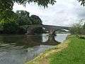 Kilsheelan Bridge
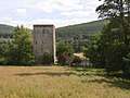 A tower house near Kilsheelan
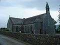 Saint Mary's Church
Places in County Tipperary | ||
|---|---|---|
| Towns | 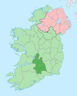 | |
| Villages |
| |
| Baronies | ||
| ||