Twentymile River
| Twentymile River | |
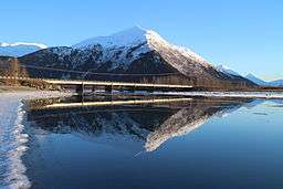 Twentymile River at its delta at the Seward Highway bridge. | |
| Country | United States |
|---|---|
| State | Alaska |
| Tributaries | |
| - left | Moraine River, Glacier River |
| City | Portage |
| Source | Various small glaciers |
| Mouth | Turnagain Arm |
| - location | Portage |
| - elevation | 0 m (0 ft) |
| - coordinates | 60°50′43″N 148°59′21″W / 60.8452°N 148.9893°WCoordinates: 60°50′43″N 148°59′21″W / 60.8452°N 148.9893°W |
| Length | 20 mi (32 km) |
 Location in Alaska | |
The Twentymile River is a river near the Kenai Peninsula in Alaska.[1] It rises in a remote valley from meltwater of several small glaciers in the Chugach Mountains and flows out into a large, wide valley where it receives the water of the Moraine and Glacier rivers. Eventually, the river empties into Turnagain Arm after flowing 20 miles (32 km) to a broad marshy delta alongside the deltas of Portage Creek and the Placer River.[2] Contrary to popular belief, the source of the river is not Twentymile Glacier.[3]
References
- ↑ "Alaska Topographic Maps by Topo Zone". TopoZone. Retrieved 2018-02-20.
- ↑ The Milepost, 59th edition, page 556, ISBN 9781892154217
- ↑ Orth, Donald J. (1967). Dictionary of Alaska Place Names. U.S. Government Printing Office.
This article is issued from
Wikipedia.
The text is licensed under Creative Commons - Attribution - Sharealike.
Additional terms may apply for the media files.