Demography
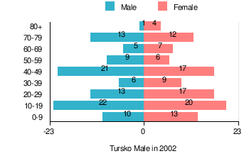
According to the 2002 Poland census, there were 205 people residing in Tursko Małe village, of whom 48.8% were male and 51.2% were female. In the village, the population was spread out with 26.3% under the age of 18, 37.6% from 18 to 44, 16.6% from 45 to 64, and 19.5% who were 65 years of age or older.[1]
Table 1. Population level of village in 2002 — by age group[1]
| SPECIFICATION |
Measure
unit |
POPULATION
(by age group in 2002) |
|---|
| TOTAL | 0-9 | 10-19 | 20-29 | 30-39 | 40-49 | 50-59 | 60-69 | 70-79 | 80 + |
| I. | TOTAL |
person | 205 | 23 | 42 | 30 | 15 | 38 | 15 | 12 | 25 | 5 |
| — | of which in |
% | 100 | 11.2 | 20.5 | 14.6 | 7.3 | 18.5 | 7.3 | 5.9 | 12.2 | 2.4 |
| 1. | BY SEX |
| A. | Males |
person | 100 | 10 | 22 | 13 | 6 | 21 | 9 | 5 | 13 | 1 |
| — | of which in |
% | 48.8 | 4.9 | 10.7 | 6.3 | 2.9 | 10.2 | 4.4 | 2.4 | 6.3 | 0.5 |
| B. | Females |
person | 105 | 13 | 20 | 17 | 9 | 17 | 6 | 7 | 12 | 4 |
| — | of which in |
% | 51.2 | 6.3 | 9.8 | 8.3 | 4.4 | 8.3 | 2.9 | 3.4 | 5.9 | 2 |
Figure 1. Population pyramid of village in 2002 — by age group and sex[1]
Table 2. Population level of village in 2002 — by sex[1]
| SPECIFICATION |
Measure
unit |
POPULATION
(by sex in 2002) |
|---|
| TOTAL | Males | Females |
| I. | TOTAL |
person | 205 | 100 | 105 |
| — | of which in |
% | 100 | 48.8 | 51.2 |
| 1. | BY AGE GROUP |
| A. | At pre-working age |
person | 54 | 26 | 28 |
| — | of which in |
% | 26.4 | 12.7 | 13.7 |
| B. | At working age. grand total |
person | 111 | 57 | 54 |
| — | of which in |
% | 54.1 | 27.8 | 26.3 |
| a. | at mobile working age |
person | 77 | 37 | 40 |
| — | of which in |
% | 37.6 | 18 | 19.6 |
| b. | at non-mobile working age |
person | 34 | 20 | 14 |
| — | of which in |
% | 16.6 | 9.8 | 6.8 |
| C. | At post-working age |
person | 40 | 17 | 23 |
| — | of which in |
% | 19.5 | 8.3 | 11.2 |
In the years 1970 last age, sorted and prepared out list part of names of localities for Tursko Małe, what you can see in table 3.
Table 3. Index of official names of localities and physiographic objects[5]
| Names of village — town |
Names of part of village
— town |
Names of physiographic objects
— nature of objects |
|---|
| I. Gromada TURSKO WIELKIE |
- Tursko Małe
|
- Kolonia
- Ogrody
- Rugałówka
|
- Góry — field
- Karczmarówka — field
- Kolonia — field, meadow
- Kopaliny — field, forest
- Ogrody — field
- Państwowe — field, meadow
- Pasterniki — meadows
- Rugałówka — field
- Tarło — field, pasture
- Turski Las — forest
- Tursko Małe — grove
- Zamczysko — forest
- Zwierzyniec — meadow
- Żabno — field, meadow, marsh
|
References
- 1 2 3 4 5 "Local Data Bank (Bank Danych Lokalnych) – Layout by NTS nomenclature (Układ wg klasyfikacji NTS)". demografia.stat.gov.pl: GUS. 10 March 2011.
- ↑ Bielec, Jan (ed.); Szwałek, Stanisława (1982). Wykaz urzędowych nazw miejscowości w Polsce. T. III: P – Ż [List of official names of localities in Poland, Vol. III: P – Ż] (in Polish). Ministry of Administration, Spatial Economy and Environmental Protection (1st ed.). Warsaw, Poland: Central Statistical Office.
- ↑ "Tursko Małe, wieś, gmina Połaniec — obszar wiejski (cz. 2), powiat staszowski, województwo świętokrzyskie" [Tursko Małe, village, Połaniec Commune — rural area (part of 2), Staszów County, Świętokrzyskie Province, Poland]. Topographical map prepared in 1:10,000 scale. Aerial and satellite orthophotomap (in Polish). Head Office of Geodesy and Cartography, Poland, Warsaw. 2011. geoportal.gov.pl. Retrieved 27 April 2011.
- ↑ "Central Statistical Office (GUS) – TERYT (National Register of Territorial Land Apportionment Journal)" (in Polish). 2008-06-01.
- ↑ Cf. Kaczmarek, Leon (ed.); Taszycki, Witold (1970). Urzędowe nazwy miejscowości i obiektów fizjograficznych. 33. Powiat staszowski województwo kieleckie [Official Names of Localities and Physiographic Objects. 33. Staszów County Kielce Voivodeship] (in Polish). Commission for Establishing Names of Localities and Physiographic Objects (to business use). Vol. 33. Warsaw, Poland: Council of Ministers' Office. Cabinet Office for bureaux of the Supervisory Boards. pp. 66, 80–82, 86, 90, 92, 95–96.
|
|---|
| Town and seat | | |
|---|
| Parts of town |
- Barszczówka
- Daszyn
- Kolonia Połaniec
- Podskale
- Rychterówka
- Żapniów
|
|---|
| Villages | |
|---|
| Part of village | |
|---|
| Colonies | |
|---|
| Farmstead | |
|---|
| Smaller locality | |
|---|
Coordinates: 50°27′N 21°21′E / 50.450°N 21.350°E / 50.450; 21.350