Tuchola
| Tuchola | |||
|---|---|---|---|
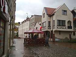 Town centre | |||
| |||
 Tuchola | |||
| Coordinates: 53°36′N 17°51′E / 53.600°N 17.850°E | |||
| Country |
| ||
| Voivodeship | Kuyavian-Pomeranian | ||
| County | Tuchola County | ||
| Gmina | Gmina Tuchola | ||
| Government | |||
| • Mayor | Tadeusz Henryk Kowalski | ||
| Area | |||
| • Total | 17.69 km2 (6.83 sq mi) | ||
| Population (2012) | |||
| • Total | 20,185 | ||
| • Density | 1,100/km2 (3,000/sq mi) | ||
| Time zone | UTC+1 (CET) | ||
| • Summer (DST) | UTC+2 (CEST) | ||
| Postal code | 89-500,89-501 | ||
| Car plates | CTU | ||
| Website | http://www.tuchola.pl | ||

Tuchola [tuˈxɔla] (German: Tuchel; Kashubian: Tëchòlô) is a town in the Kuyavian-Pomeranian Voivodeship in northern Poland. The Pomeranian town, which is the seat of Tuchola County, had a population of 13,418 as of 2013.
Geographical location
Tuchola lies about 50 kilometres (31 miles) north of Bydgoszcz, close to the Tuchola Forests. Forest areas to the east and north of the town form the protected area of Tuchola Landscape Park.
History
Settlement around Tuchola dates from 980, while the town was first mentioned in 1287. The place was one of the strongholds of the count of Nowe Peter Swienca, who owned a fortified domicile in the area. In 1330 Tuchola came into possession of the Teutonic Order. It received Culm law in 1346 from Heinrich Dusemer, the Grand Master of the Teutonic Knights.
After the Order's defeat in the Battle of Grunwald on July 14, 1410, a Polish-Lithuanian army captured the town on November 5, 1410, but the Order regained the town in the First Peace of Thorn in 1411. At the end of the Thirteen Years' War (1454–1466), however, it was ceded to Poland in the Second Peace of Thorn and became part of Royal Prussia.
Under the First Partition of Poland in 1772, Royal Prussia was annexed by the Kingdom of Prussia. On May 17, 1781, the Church of St. Bartholomäus and vast parts of the town burned down. Around 1785 there existed 148 households inside Tuchel, and the town owned both the village of Kelpin and the small estate named Wymislawe.[1] During the reign of Prussian King Frederick the Great (1740-1786), the town was built up again, and German Protestants obtained a church in the town hall.[2] With the unification of Germany under Prussian hegemony in 1871, Tuchel became part of the German Empire.
During World War I, a prisoner-of-war camp was established near Tuchel. After the town was transferred to the Second Polish Republic in 1920 following the Treaty of Versailles, and officially became Tuchola, the POW camp became known as Camp No. 7.
Beginning in the autumn of 1920 during Polish-Soviet war, thousands of captured Red Army men were placed in the camp of Тuchola. These prisoners of war (POWs) lived in crude dugouts, and hunger, cold, and infectious diseases killed many. According to historians Zbigniew Karpus and Waldemar Rezmer, up to 2000 prisoners died in the camp before it was closed in 1923.[3] However, according to other sources the number of died prisoners was much higher. Colonel Ignacy Matuszewski reported that about 22 thousand Red Army men died in the camp of Tuchola.[4]
During World War II, Tuchola, along with the rest of the region, was annexed by Nazi Germany. After the German defeat, the town reverted to Poland.
Number of inhabitants by year
| Year | Number |
|---|---|
| 1772 | 490 |
| 1802 | 1,159 |
| 1805 | 1,251 |
| 1831 | 1,283 |
| 1837 | 1,435 |
| 1843 | 1,801 |
| 1865 | 2,579 |
| 1875 | 2,780 |
| 1880 | 3,066 |
| 1890 | 2,826 |
| 1905 | 3,448 |
| 1931 | 5,477 |
| 1943 | 7,086 |
| 2012 | 20,185 |
Education
- Higher School of Environmental Management (Polish: Wyższa Szkoła Zarządzania Środowiskiem)
Famous residents
- Louis Lewin (1850–1929), physician, pharmacologist, toxicologist in Berlin
- Max Liebermann von Sonnenberg (1848–1911), German politician
- Johannes Holzmann (Senna Hoy) (1882–1914), anarchist author
- Wilhelm Ambrosius (1903–1955), Kriegsmarine officer
- Marcin Jędrzejewski - speedway rider and current member of Polish national junior team.
- Tadeusz Zwiefka - popular TV journalist, and a Civic Platform Member of European Parliament.
External links
Footnotes
- ↑ Johann Friedrich Goldbeck: Volständige Topographie des Königreichs Preussen, Part II: Topograpie von West-Preussen, Marienwerder 1789, p. 76, no. 2) (in German).
- 1 2 August Eduard Preuß: Preußische Landes- und Volkskunde, Königsberg 1835, p. 383–384, no. 16.
- ↑ Pamyatnykh, Alex (October 2005). "ПЛЕННЫЕ КРАСНОАРМЕЙЦЫ В ПОЛЬСКИХ ЛАГЕРЯХ (Red Army prisoners in the Polish camps)". Нoвaя Poльшa. Retrieved 2013-04-19.
- ↑ Blinova, Ekatarina (April 2016). "Ghosts of the Past: The Story of Red Army Captives in Poland". Sputnik International. Retrieved 2016-04-05.
- ↑ Ludwig von Baczko: Handbuch der Geschichte, Erdbeschreibung und Statistik Preussens, Vol. II, Part 2, Königsberg and Leipzig 1803, p. 69 (in German).
- ↑ August Carl von Holsche: Geographie und Statistik von West-, Süd- und Neu-Ostpreußen. Nebst einer kurzen Geschichte des Königreichs Polen bis zu dessen Zertheilung. Vol. 3, Berlin 1807, p. 110 (in German).
- ↑ W. F. C. Starke: Beiträge zur Kenntniß dere bestehenden Gerichtsverfassung und der neuesten Resutate der Justizverwaltung und des Preussischen Staates, Vol. II, Part 1: Preußen, Posen, Pommern, Schlesien. Berlin 1839, p. 158 (in German).
- ↑ Archiv der Pharmacie, Vol. XCII, Hannover 1845, p. 256 (in German).
- ↑ Meyers Großes Konversatins-Lexikon, 6th edition, Vol. 19, Leizig and Vienna 1909, pp. 791-792.
- ↑ Michael Rademacher: Deutsche Verwaltungsgeschichte Provinz Westpreußen (2006) (in German).
- ↑ Topographisch-statistisches Handbuch für den Regierungsbezirk Marienwerder, Danzig 1868; see III. Kreis Konitz, pp. 50-51, entry no. 349 (in German).
See also
Coordinates: 53°36′N 17°51′E / 53.600°N 17.850°E
| Seat |  | |
|---|---|---|
| Urban-rural gmina | ||
| Rural gminas | ||