Tsuno, Miyazaki
| Tsuno 都農町 | |||
|---|---|---|---|
| Town | |||
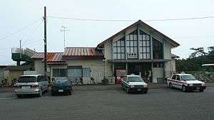 Tsuno Station | |||
| |||
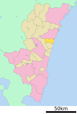 Location of Tsuno in Miyazaki Prefecture | |||
 Tsuno Location in Japan | |||
| Coordinates: 32°16′25″N 131°31′47″E / 32.27361°N 131.52972°ECoordinates: 32°16′25″N 131°31′47″E / 32.27361°N 131.52972°E | |||
| Country | Japan | ||
| Region | Kyushu | ||
| Prefecture | Miyazaki Prefecture | ||
| District | Koyu | ||
| Area | |||
| • Total | 102.33 km2 (39.51 sq mi) | ||
| Population (October 1, 2016) | |||
| • Total | 10,343 | ||
| • Density | 100/km2 (260/sq mi) | ||
| Symbols | |||
| • Tree | Ginkgo biloba | ||
| • Flower | Orchidaceae | ||
| • Bird | Japanese white-eye | ||
| Time zone | UTC+9 (JST) | ||
| Website |
www | ||


Tsuno (都農町 Tsuno-chō) is a town located in Koyu District, Miyazaki Prefecture, Japan.
As of October 2016, the town has an estimated population of 10,343 and the density of 100 persons per km². The total area is 102.33 km².
Geography
Neighbouring municipalities
- Miyazaki Prefecture
Transportation
Railway
Highways
External links

- Tsuno official website (in Japanese)
| Core city | |
|---|---|
| Cities | |
| Districts | |
This article is issued from
Wikipedia.
The text is licensed under Creative Commons - Attribution - Sharealike.
Additional terms may apply for the media files.