Tsinjoarivo, Ambatolampy
| Tsinjoarivo | |
|---|---|
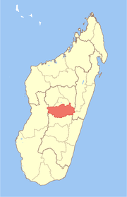
 Tsinjoarivo Location in Madagascar | |
| Coordinates: 19°38′S 47°41′E / 19.633°S 47.683°E | |
| Country |
|
| Region | Vakinankaratra |
| District | Ambatolampy |
| Elevation[1] | 1,561 m (5,121 ft) |
| Population (2001)[2] | |
| • Total | 20,000 |
| Time zone | UTC3 (EAT) |
Tsinjoarivo is a town and commune in Madagascar. It is located in the district of Ambatolampy, which is in the Vakinankaratra Region, and is alongside the Onive River. The population of the commune was estimated to be approximately 20,000 in 2001 commune census.[2]
Primary and junior level secondary education are available in town. The majority 99% of the population of the commune are farmers. The most important crop is rice, while other important products are beans, maize, cassava and potatoes. Services provide employment for 1% of the population.[2]
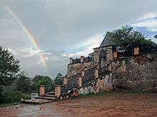
Due to its outstanding universal cultural value, the city, along with its associated rova, was added onto the UNESCO Tentative List of World Heritage Sites in Madagascar on November 14, 1997, in the cultural category.[3]
Notable waterfalls are located along the Onive on the southwest side of the town.[4]
See also
References and notes
- ↑ Estimated based on DEM data from Shuttle Radar Topography Mission
- 1 2 3 "ILO census data". Cornell University. 2002. Retrieved 2008-04-22.
- ↑ Site et Rova de Tsinjoarivo - UNESCO World Heritage Centre
- ↑ Madagascar, 2008-2009, p. 245 (Le Petit Futé 2008) (in French)