Tsentralny City District, Barnaul
Tsentralny City District (Russian: Центра́льный райо́н, lit. Central District) is a district of the city of Barnaul, Altai Krai, Russia. Its area is ca. 145 square kilometers (56 sq mi).[1] Population: 91,445 (2010 Census);[2] 86,816 (2002 Census);[3] 86,842 (1989 Census).[4]
Overview
Established on February 7, 1938,[5] it is one of the oldest city districts. It serves as an economic, historical, and transportation core of Barnaul. It borders the Ob River in the southeast and several districts in the north.
Population
After 2002, the following inhabited localities were merged into the city district: Yuzhny, Lebyazhye, Tsentralny, Belmesevo, Konyukhi, Mokhnatushka, Chernitsk, Yagodnoye, Borzovaya Zaimka, Sadovodov, Plodopitomnik, Polzunovo, and Zaton, which led to the significant increase of the population.
Sights
Places of interest include Demidov Square, Red Department Store, Nagorny Park, Tsentralny Park, Pokrovsky Cathedral, Polyakov's House, and more.
Gallery
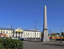 Demidov Square (Krasnoarmeysky Avenue)
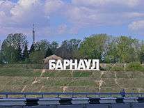 "Barnaul" sign in Nagorny Park
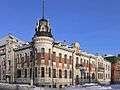 Polyakov House
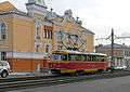 Tram on Polzunova Street
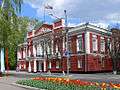 Barnaul City Duma
 Rodina Cinema
References
- ↑ Официальный сайт Барнаула. Справка о районе. Archived June 28, 2008, at the Wayback Machine. (Official website of Barnaul. Information about Tsentralny District) (in Russian)
- ↑ Russian Federal State Statistics Service (2011). "Всероссийская перепись населения 2010 года. Том 1" [2010 All-Russian Population Census, vol. 1]. Всероссийская перепись населения 2010 года (2010 All-Russia Population Census) (in Russian). Federal State Statistics Service. Retrieved June 29, 2012.
- ↑ Russian Federal State Statistics Service (May 21, 2004). "Численность населения России, субъектов Российской Федерации в составе федеральных округов, районов, городских поселений, сельских населённых пунктов – районных центров и сельских населённых пунктов с населением 3 тысячи и более человек" [Population of Russia, Its Federal Districts, Federal Subjects, Districts, Urban Localities, Rural Localities—Administrative Centers, and Rural Localities with Population of Over 3,000] (XLS). Всероссийская перепись населения 2002 года [All-Russia Population Census of 2002] (in Russian). Retrieved August 9, 2014.
- ↑ Demoscope Weekly (1989). "Всесоюзная перепись населения 1989 г. Численность наличного населения союзных и автономных республик, автономных областей и округов, краёв, областей, районов, городских поселений и сёл-райцентров" [All Union Population Census of 1989: Present Population of Union and Autonomous Republics, Autonomous Oblasts and Okrugs, Krais, Oblasts, Districts, Urban Settlements, and Villages Serving as District Administrative Centers]. Всесоюзная перепись населения 1989 года [All-Union Population Census of 1989] (in Russian). Институт демографии Национального исследовательского университета: Высшая школа экономики [Institute of Demography at the National Research University: Higher School of Economics]. Retrieved August 9, 2014.
- ↑ Решение Барнаульской городской Думы №286 от 27 февраля 2006 г. "Об утверждении положения о Центральном районе в городе Барнауле и Администрации Центрального района города Барнаула" в редакции Решения Барнаульской городской Думы №602 от 15 июня 2007 г. (Resolution of Barnaul City Duma #286 of February 27, 2006 On Confirmation of the Resolution on Tsentralny District in the City of Barnaul and on the Administration of Tsentralny District of the City of Barnaul, as revised by the Resolution of Barnaul City Duma #602 of June 15, 2007)