Tschingel (Oberhasli)
- For the nearby peak of the same name, some 7 km to the west, see Tschingel (Axalp).
| Tschingel | |
|---|---|
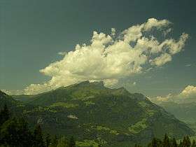 The Tschingel (centre) seen from the east side | |
| Highest point | |
| Elevation | 2,326 m (7,631 ft) |
| Prominence | 21 m (69 ft) [1] |
| Coordinates | 46°42′13.4″N 8°8′26.7″E / 46.703722°N 8.140750°ECoordinates: 46°42′13.4″N 8°8′26.7″E / 46.703722°N 8.140750°E |
| Geography | |
 Tschingel Location in Switzerland | |
| Location | Bernese Oberland, Switzerland |
| Parent range | Bernese Alps |
The Tschingel (2,326 m) is a mountain of the Bernese Alps, overlooking Meiringen in the Bernese Oberland. It constitutes the eastern end of the Grindelgrat, a ridge descending from the Garzen summit (2,710 m). The summit is on the border between Meiringen and Schattenhalb municipalities.
The toponym Tschingel or Zingel is comparatively frequent in Central Switzerland. It is a derivation of Latin cingulum "girdle, belt" and refers to a horizontal band of naked rock, or striations in a rock face.[2]
References
- ↑ Retrieved from the Swisstopo topographic maps and Google Earth. The key col is located west of the summit at 2,305 metres.
- ↑ Weibel, Viktor (1976): Die Staffelung romanischer Elemente der innerschweizerischen Bergnamengebung. In: Beiträge zur Schweizer Namenkunde 14, 293-308. Heinrich Schmid, 'An der Westgrenze des Rätoromanischen: verkappte Zeugen einstigen Romanentums im Linthgebiet und benachbarten Teilen der Innerschweiz, Vox Romanica 39 (1980), 155ff.; cited after ortsnamen.ch.
External links
This article is issued from
Wikipedia.
The text is licensed under Creative Commons - Attribution - Sharealike.
Additional terms may apply for the media files.