1980 Pacific typhoon season
| 1980 Pacific typhoon season | |
|---|---|
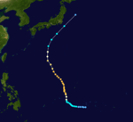
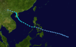
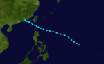
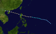
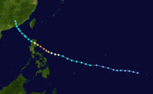
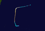
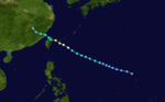
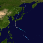
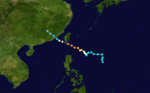
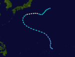
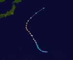
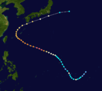
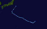
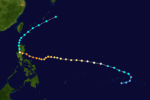
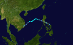
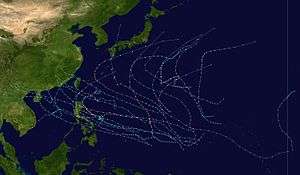 Season summary map | |
| Seasonal boundaries | |
| First system formed | February 12, 1980 |
| Last system dissipated | December 21, 1980 |
| Strongest storm | |
| Name | Wynne |
| • Maximum winds |
220 km/h (140 mph) (10-minute sustained) |
| • Lowest pressure | 890 hPa (mbar) |
| Seasonal statistics | |
| Total depressions | 44 |
| Total storms | 24 |
| Typhoons | 15 |
| Super typhoons | 2 (unofficial) |
| Total fatalities | 131 total |
| Total damage | Unknown |
| Related articles | |
The 1980 Pacific typhoon season has no official bounds; it ran year-round in 1980, but most tropical cyclones tend to form in the northwestern Pacific Ocean between June and December. These dates conventionally delimit the period of each year when most tropical cyclones form in the northwestern Pacific Ocean. Tropical storms which formed in the entire west Pacific basin were assigned a name by the Joint Typhoon Warning Center. Tropical depressions that enter or form in the Philippine area of responsibility are assigned a name by the Philippine Atmospheric, Geophysical and Astronomical Services Administration or PAGASA. This can often result in the same storm having two names.
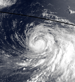
A total of 28 tropical depressions formed this year in the Western Pacific, of which 24 became tropical storms. Beginning in March, tropical cyclones formed in each subsequent month through December. Of the 28, 15 storms reached typhoon intensity, of which 2 reached super typhoon strength. Seven tropical cyclones moved through the Philippines this season.
Seasonal summary
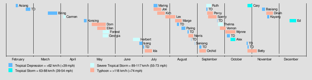
A total of 28 tropical depressions formed this year in the Western Pacific, of which 24 became tropical storms. Of the 28, 15 storms reached typhoon intensity, of which 2 reached super typhoon strength. Seven tropical cyclones moved through the Philippines this season.
Systems
Tropical Depression Asiang
| Tropical depression (PAGASA) | |
 | |
| Duration | February 12 – February 14 |
|---|---|
| Peak intensity | 55 km/h (35 mph) (10-min) |
Tropical Depression 01W (Biring)
| Tropical depression (JMA) | |
| Tropical depression (SSHWS) | |
  | |
| Duration | March 19 – March 29 |
|---|---|
| Peak intensity | 55 km/h (35 mph) (1-min) 1002 hPa (mbar) |
1W hit the Philippines in March.
Severe Tropical Storm Carmen
| Severe tropical storm (JMA) | |
| Tropical storm (SSHWS) | |
  | |
| Duration | April 5 (Entered basin) – April 7 (Exited basin) |
|---|---|
| Peak intensity | 110 km/h (70 mph) (10-min) 985 hPa (mbar) |
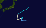
On April 4, a tropical depression formed just east of the International Date Line.[1] At the time, the Joint Typhoon Warning Center (JTWC) designated it tropical depression 02W. As it moved generally northwestwards, it strengthened into a tropical storm just before crossing the dateline, but only received a name in the northwest Pacific, being designated Carmen.[1] After peaking with maximum sustained winds of 70 mph (110 km/h) on April 6,Carmen recurved northeast and crossed the International Date Line, entering the central Pacific on April 7.[1] The JTWC subsequently relinquished responsibility to the Central Pacific Hurricane Center. Carmen lost its initial motion and stalled in the area, ultimately weakening in to a tropical depression on April 8.[1] The depression dissipated the following day and the remnant low returned to western Pacific.[1]
Tropical Depression Konsing
| Tropical depression (PAGASA) | |
|
| |
| Duration | April 28 – May 1 |
|---|---|
| Peak intensity | 55 km/h (35 mph) (10-min) |
Typhoon Dom (Ditang)
| Typhoon (JMA) | |
| Category 2 typhoon (SSHWS) | |
  | |
| Duration | May 7 – May 22 |
|---|---|
| Peak intensity | 155 km/h (100 mph) (10-min) 960 hPa (mbar) |
Dom brushed the Philippines.
Typhoon Ellen
| Typhoon (JMA) | |
| Category 3 typhoon (SSHWS) | |
  | |
| Duration | May 13 – May 22 |
|---|---|
| Peak intensity | 195 km/h (120 mph) (10-min) 930 hPa (mbar) |
Ellen had no effect on land.
Severe Tropical Storm Forrest (Gloring)
| Severe tropical storm (JMA) | |
| Tropical storm (SSHWS) | |
  | |
| Duration | May 19 – May 26 |
|---|---|
| Peak intensity | 100 km/h (65 mph) (10-min) 992 hPa (mbar) |
Forrest hit the Philippines.
Severe Tropical Storm Georgia (Edeng)
| Severe tropical storm (JMA) | |
| Tropical storm (SSHWS) | |
  | |
| Duration | May 19 – May 25 |
|---|---|
| Peak intensity | 100 km/h (65 mph) (10-min) 980 hPa (mbar) |
Georgia threatened Hong Kong.
Severe Tropical Storm Herbert (Huaning)
| Severe tropical storm (JMA) | |
| Tropical storm (SSHWS) | |
  | |
| Duration | June 22 – June 29 |
|---|---|
| Peak intensity | 95 km/h (60 mph) (10-min) 990 hPa (mbar) |
Herbert also threatened Hong Kong, and made landfall in Hainan and later in mainland China
Tropical Depression Isang
| Tropical depression (JMA) | |
|
| |
| Duration | June 29 – July 2 |
|---|---|
| Peak intensity | Winds not specified 998 hPa (mbar) |
Typhoon Ida (Lusing)
| Typhoon (JMA) | |
| Tropical storm (SSHWS) | |
  | |
| Duration | July 5 – July 13 |
|---|---|
| Peak intensity | 130 km/h (80 mph) (10-min) 980 hPa (mbar) |
Ida passed south of Taiwan and moved ashore in China just north of Hong Kong
Typhoon Joe (Nitang)
| Typhoon (JMA) | |
| Category 3 typhoon (SSHWS) | |
  | |
| Duration | July 15 – July 23 |
|---|---|
| Peak intensity | 155 km/h (100 mph) (10-min) 940 hPa (mbar) |
Typhoon Joe, which developed on July 16 from the near equatorial trough, hit eastern Luzon on the 20th. It weakened over island, but restrengthened in the South China Sea to a 100 mph typhoon before making landfall on Hainan Island on the 22nd. Joe made its final landfall that night on northern Vietnam before dissipating on the 23rd. Joe caused heavy damage and an estimated 19 deaths in the Philippines with many more in Vietnam. The exact numbers are unknown due to Typhoon Kim hitting just four days later.
Tropical Depression 10W (Maring)
| Tropical depression (JMA) | |
| Tropical depression (SSHWS) | |
 | |
| Duration | July 15 – July 19 |
|---|---|
| Peak intensity | 55 km/h (35 mph) (10-min) 1000 hPa (mbar) |
10W threatened the Philippines.
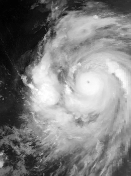
Super Typhoon Kim (Osang)
| Typhoon (JMA) | |
| Category 4 super typhoon (SSHWS) | |
  | |
| Duration | July 19 – July 27 |
|---|---|
| Peak intensity | 185 km/h (115 mph) (10-min) 910 hPa (mbar) |
Like Typhoon Joe, Kim formed from the near equatorial monsoon trough on July 19. It tracked quickly westward-northwest underneath a subtropical ridge, reaching tropical storm strength on the July 21 and typhoon strength on July 23. After developing an eye, Kim began to rapidly intensify, and during the afternoon of July 24, peaked in intensity as a super typhoon. Several hours later, Kim made landfall over the Philippines, but the storm had weakened considerably by this time. Throughout the Philippines, 40 people were killed, two via drownings, and 19,000 others were directly affected. A total of 12,000 homes were destroyed and 5,000 villages received flooded. Less than a week earlier, the same areas were affected by Joe; however, Kim was considered the more damaging of the two typhoons. Land interaction took toll on Kim, and upon entering the South China Sea, was down below typhoon intensity. Kim continued northwestward, but with its disrupted circulation, it remained a tropical storm until hitting southern China July 27 to the northeast of Hong Kong, where damage was minor. Later that day, Kim dissipated.
Typhoon Lex
| Typhoon (JMA) | |
| Category 1 typhoon (SSHWS) | |
  | |
| Duration | July 28 – August 8 |
|---|---|
| Peak intensity | 140 km/h (85 mph) (10-min) 960 hPa (mbar) |
Lex stayed at sea.
Typhoon Marge
| Typhoon (JMA) | |
| Category 3 typhoon (SSHWS) | |
  | |
| Duration | August 8 – August 15 |
|---|---|
| Peak intensity | 165 km/h (105 mph) (10-min) 945 hPa (mbar) |
Marge stayed at sea.
Tropical Depression 14W (Paring)
| Tropical depression (JMA) | |
| Tropical depression (SSHWS) | |
 | |
| Duration | August 15 – August 19 |
|---|---|
| Peak intensity | 55 km/h (35 mph) (10-min) 1000 hPa (mbar) |
14W was short-lived.
Typhoon Norris (Reming)
| Typhoon (JMA) | |
| Category 2 typhoon (SSHWS) | |
  | |
| Duration | August 23 – August 28 |
|---|---|
| Peak intensity | 175 km/h (110 mph) (10-min) 945 hPa (mbar) |
Norris hit Taiwan.
Typhoon Orchid (Toyang)
| Typhoon (JMA) | |
| Category 2 typhoon (SSHWS) | |
  | |
| Duration | September 4 – September 11 |
|---|---|
| Peak intensity | 130 km/h (80 mph) (10-min) 960 hPa (mbar) |
The monsoon trough spawned a tropical depression on September 1. It tracked northwestward, remaining disorganized and dissipating on the 5th. Another tropical depression developed to the east of the old circulation, quickly becoming the primary circulation and intensifying to a tropical storm on the 6th. With generally weak steering currents, Orchid looped three times on its track, strengthening to a typhoon on the 9th and reaching a peak of 95 mph winds on the 10th. Early on the 11th the storm hit southwestern Japan, and became extratropical that day over the Japan Sea. Orchid caused considerable damage from high winds and rain, resulting in at least nine casualties with 112 missing. It was also responsible for the September 10th loss of the MV Derbyshire, a large 91,655 ton bulk carrier which sank on 9 September with all 44 hands on board due to very rough seas. It remains the largest British flagged ship to be lost at sea.
Tropical Depression 16W
| Tropical depression (JMA) | |
| Tropical depression (SSHWS) | |
 | |
| Duration | September 6 – September 7 |
|---|---|
| Peak intensity | 55 km/h (35 mph) (10-min) 998 hPa (mbar) |
16W did not last long.
Typhoon Percy (Undang)
| Typhoon (JMA) | |
| Category 4 typhoon (SSHWS) | |
  | |
| Duration | September 13 – September 19 |
|---|---|
| Peak intensity | 185 km/h (115 mph) (10-min) 915 hPa (mbar) |
Typhoon Percy struck southern Taiwan on September 18. A day later, with its circulation and low-level inflow greatly disrupted, 50 mph Tropical Storm Percy hit southeastern China, and dissipated later that night. 7 people died in the storm, with moderate damage on its path.
Severe Tropical Storm Ruth
| Severe tropical storm (JMA) | |
| Category 1 typhoon (SSHWS) | |
  | |
| Duration | September 12 – September 16 |
|---|---|
| Peak intensity | 100 km/h (65 mph) (10-min) 980 hPa (mbar) |
A monsoon depression transitioned into a tropical depression on September 13 in the South China Sea. It initially moved southward, then turned to the west-northwest, reaching tropical storm strength late on the 13th. Ruth crossed Hainan Island on the 14th and 15th, becoming a typhoon late on the 15th before hitting northern Vietnam on the 16th. The typhoon left nearly half a million homeless, with 106 known dead or missing in Vietnam.
Typhoon Sperry
| Typhoon (JMA) | |
| Category 1 typhoon (SSHWS) | |
  | |
| Duration | September 14 – September 23 |
|---|---|
| Peak intensity | 120 km/h (75 mph) (10-min) 975 hPa (mbar) |
Sperry did not affect land.
Severe Tropical Storm Thelma
| Severe tropical storm (JMA) | |
| Tropical storm (SSHWS) | |
  | |
| Duration | September 25 – September 30 |
|---|---|
| Peak intensity | 100 km/h (65 mph) (10-min) 975 hPa (mbar) |
Thelma stayed at sea as a tropical storm.
Typhoon Vernon
| Typhoon (JMA) | |
| Category 3 typhoon (SSHWS) | |
  | |
| Duration | September 27 – October 3 |
|---|---|
| Peak intensity | 175 km/h (110 mph) (10-min) 935 hPa (mbar) |
Vernon was a potent typhoon that stayed from land.
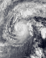
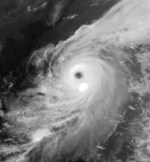
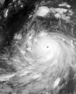
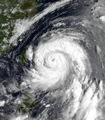
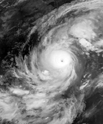
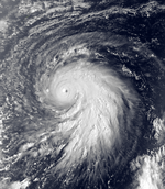
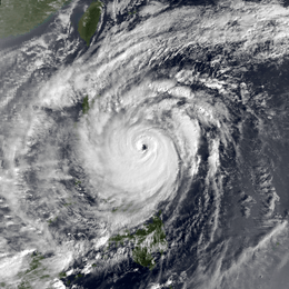
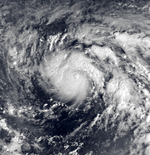
Typhoon Wynne (Welpring)
| Typhoon (JMA) | |
| Category 5 super typhoon (SSHWS) | |
  | |
| Duration | October 3 – October 14 |
|---|---|
| Peak intensity | 220 km/h (140 mph) (10-min) 890 hPa (mbar) |
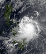
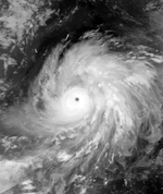
Wynne was the strongest storm of the season, reaching a peak of 175 mph (282 km/h) winds and a pressure of 890 mbar. As a strengthening category 1 storm, it rapidly intensified to become the strongest storm of the season.
Tropical Storm Alex
| Tropical storm (JMA) | |
| Tropical storm (SSHWS) | |
  | |
| Duration | October 9 – October 14 |
|---|---|
| Peak intensity | 65 km/h (40 mph) (10-min) 998 hPa (mbar) |
Alex stayed over water.
Typhoon Betty (Aring)
| Typhoon (JMA) | |
| Category 4 typhoon (SSHWS) | |
  | |
| Duration | October 28 – November 7 |
|---|---|
| Peak intensity | 185 km/h (115 mph) (10-min) 925 hPa (mbar) |
Betty hit the Philippines as a strong typhoon.
Tropical Storm Cary (Yoning)
| Tropical storm (JMA) | |
| Tropical storm (SSHWS) | |
  | |
| Duration | October 28 – November 2 |
|---|---|
| Peak intensity | 85 km/h (50 mph) (10-min) 996 hPa (mbar) |
Cary moved into the South China Sea.
Tropical Depression Basiang
| Tropical depression (JMA) | |
|
| |
| Duration | November 13 – November 16 |
|---|---|
| Peak intensity | Winds not specified 1004 hPa (mbar) |
Typhoon Dinah
| Typhoon (JMA) | |
| Category 3 typhoon (SSHWS) | |
  | |
| Duration | November 18 – November 25 |
|---|---|
| Peak intensity | 165 km/h (105 mph) (10-min) 950 hPa (mbar) |
Dinah did not affect land.
It hit the Northern Mariana Islands directly. Saipan sustained significant damage.
Tropical Depression Kayang
| Tropical depression (JMA) | |
|
| |
| Duration | November 19 – November 21 |
|---|---|
| Peak intensity | Winds not specified 1004 hPa (mbar) |
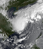
Tropical Storm Ed (Dorang)
| Tropical storm (JMA) | |
| Tropical storm (SSHWS) | |
  | |
| Duration | December 14 – December 21 |
|---|---|
| Peak intensity | 85 km/h (50 mph) (10-min) 990 hPa (mbar) |
A tropical disturbance was first observed near Yap on the 14th of December. The disturbance moved westward at between 12 and 15 kt (22 to 28 km/hr) as its convective activity and overall organization continued to improve. A Tropical Cyclone Formation Alert (TCFA) was issued when a reconnaissance aircraft observed a well-defined low-level circulation with a minimum sea-level pressure of 1004 mb. The disturbance was upgraded to Tropical Storm Ed on December 15. It then became evident from synoptic analyses that Ed was moving into an area which was unfavorable for continued development. Eventually, after most of the storm's convection had been sheared off, Ed’s surface center began to track to the southwest under the influence of the strong surface ridge to the north. Dissipation as a tropical cyclone was completed on the 24th as the remnants of Ed moved into northern Mindanao.
Storm names
During the season 24 named tropical cyclones developed in the Western Pacific and were named by the Joint Typhoon Warning Center, when it was determined that they had become tropical storms. These names were contributed to a revised list which started on 1979.
| Carmen | Dom | Ellen | Forrest | Georgia | Herbert | Ida | Joe | Kim | Lex | Marge | Norris |
| Orchid | Percy | Ruth | Sperry | Thelma | Vernon | Wynne | Alex | Betty | Cary | Dinah | Ed |
Philippines
| Asiang | Biring | Konsing | Ditang | Edeng |
| Gloring | Huaning | Isang | Lusing | Maring |
| Nitang | Osang | Paring | Reming | Seniang |
| Toyang | Unsang | Welpring | Yoning | |
| Auxiliary list | ||||
|---|---|---|---|---|
| Aring | ||||
| Basiang | Kayang | Dorang | Enang (unused) | Grasing (unused) |
The Philippine Atmospheric, Geophysical and Astronomical Services Administration uses its own naming scheme for tropical cyclones in their area of responsibility. PAGASA assigns names to tropical depressions that form within their area of responsibility and any tropical cyclone that might move into their area of responsibility. Should the list of names for a given year prove to be insufficient, names are taken from an auxiliary list, the first 6 of which are published each year before the season starts. Names not retired from this list will be used again in the 1984 season. This is the same list used for the 1976 season. PAGASA uses its own naming scheme that starts in the Filipino alphabet, with names of Filipino female names ending with "ng" (A, B, K, D, etc.). Names that were not assigned/going to use are marked in gray.
See also
- List of Pacific typhoon seasons
- 1980 Pacific hurricane season
- 1980 Atlantic hurricane season
- 1980 North Indian Ocean cyclone season
- Southern Hemisphere tropical cyclone seasons: 1979–80, 1980–81
References
External links
- Japan Meteorological Agency
- Joint Typhoon Warning Center.
- China Meteorological Agency
- National Weather Service Guam
- Hong Kong Observatory
- Macau Meteorological Geophysical Services
- Korea Meteorological Agency
- Philippine Atmospheric, Geophysical and Astronomical Services Administration
- Taiwan Central Weather Bureau
- Digital Typhoon – Typhoon Images and Information
- Typhoon2000 Philippine typhoon website