Tropical Storm Christine (1973)
| Tropical storm (SSHWS/NWS) | |
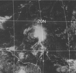 Satellite image of Tropical Storm Christine on September 1, 1973 | |
| Formed | August 25, 1973 |
|---|---|
| Dissipated | September 4, 1973 |
| Highest winds |
1-minute sustained: 70 mph (110 km/h) |
| Lowest pressure | 996 mbar (hPa); 29.41 inHg |
| Fatalities | 1 indirect |
| Areas affected | Leeward Islands and Puerto Rico |
| Part of the 1973 Atlantic hurricane season | |
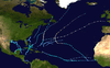
Tropical Storm Christine was the easternmost forming Atlantic tropical cyclone on record.[1] Forming as a tropical depression over the country of Guinea on August 25, 1973, the system tracked nearly due west for several days before intensifying into a tropical storm on August 28. However, the National Hurricane Center did not issue their first advisory on the system until its intensity was confirmed by a reconnaissance aircraft on August 30. Turning slightly northward, Christine gradually intensified, attaining its peak strength on September 2. At that time, the storm had winds of 70 mph (110 km/h) and a minimum pressure of 996 mbar (hPa; 29.41 inHg), just below hurricane status. Shortly after, increasing wind shear caused the system to quickly weaken. By September 4, Christine had been downgraded to a tropical depression as it tracked through the Leeward Islands. After degenerating into a tropical wave, the cyclone's remnants fully dissipated on September 6.
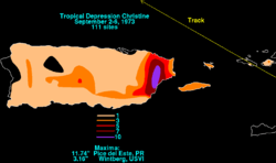
Although Christine had weakened to a tropical depression by the time it passed through the Leeward Islands, heavy rains from the storm, peaking at 11.74 in (298 mm), caused flooding in Puerto Rico. Over 600 homes were flooded and dozens of families had to be evacuated from several towns. One person died from electrocution after stepping on a downed wire on a flooded street. Minor damage was recorded in the Virgin Islands, mainly downed power lines which left roughly 500 people without telephone service.
Meteorological history
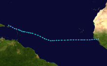
Tropical Storm Christine originated from a tropical wave over Africa in late-August.[2] As it neared the Atlantic Ocean, the wave spawned a tropical depression at 14.0°W, over the country of Guinea, on August 25.[2] The formation of this depression was farther east than any other tropical cyclone on record in the Atlantic hurricane basin, although storms may have gone undetected prior to the start of satellite imagery in the 1960s. This record would not be approached by any other storm until Hurricane Jeanne in 1998, which formed at 17.4°W.[1] This was unlike most cyclone producing waves which travel several hundred miles over water before spawning a depression.[2] Tracking nearly due west, the depression moved over water several hours later and bypassed the Cape Verde Islands on August 27.[2]
The following day, the depression intensified into a tropical storm;[3] however, advisories were not issued by the National Hurricane Center (NHC) on the system until August 30 because of the lack of reconnaissance aircraft data. It was determined that Christine had become a tropical storm by this time after receiving reports of gale-force winds from a German cargo ship in the vicinity of the storm.[2] The first advisory from the NHC came after a reconnaissance plane found sustained winds of 50 mph (85 km/h) and a barometric pressure of 1007 mbar (hPa; 29.74 inHg). At that time, Christine was located roughly 1000 mi (1,500 km) east of Trinidad.[2] Although the storm was relatively disorganized by this point, satellite imagery showed large outer bands extending hundreds of miles (kilometres) from the storm.[4]
By August 31, the storm began to slow[5] and turn towards the west-northwest.[3] The NHC noted that they did not have a firm grip on the storm and were unsure of its future track and intensity.[5] Below average sea surface temperatures ahead of the system would hamper significant development.[6] Continuing on this track, Christine gradually intensified and on September 2, the storm attained its peak intensity just below hurricane-status while situated roughly 300 mi (500 km) east of Guadeloupe.[2] At this time, a reconnaissance aircraft recorded[2] sustained winds of 70 mph (110 km/h) and a minimum pressure of 996 mbar (hPa; 29.41 inHg).[3] Shortly after Christine attained this intensity, increasing wind shear caused the storm to weaken as it neared the Leeward Islands.[2][7]
The NHC noted that a trough ahead of Christine would determine the future of the storm. This trough would either merge with the storm and allow significant intensification, or remain separate and cause Christine to dissipate.[8] By September 3, the low-level circulation had been displaced from all convective activity[2] and Christine weakened to a tropical depression.[3] Several hours after weakening, the depression passed over Antigua with winds of 35 mph (55 km/h). The following day, the system degenerated into a tropical wave near the northeastern coast of the Dominican Republic. The remnants of Christine were monitored by the NHC for several days before dissipating near the trough on September 6.[2][8]
Observation
Throughout its existence, Christine was monitored by astronauts in the Skylab 3 project.[9][10] During this project, active and passive microwave satellite imagery was used for the first time to determine the wind speed within a tropical cyclone. This was accomplished after the removal of regions of heavy rain from the data, a factor that gives inaccurate wind readings.[11]
Preparations and impact
On September 2, the National Hurricane Center issued gale warnings and hurricane watches for Guadeloupe, Desirade, Antigua and Barbuda. Later that day, the gale warnings were expanded southward to include islands north of Dominica. After Christine weakened to a tropical depression, the NHC discontinued all watches and warnings for the Leeward Islands.[2] Schools were closed in Puerto Rico and the United States Virgin Islands as a precaution. Six scientists had to be evacuated from the small island of Aves once the storm posed a threat to them.[12] On St. Thomas, nine emergency shelters were opened, mainly in schools.[13] On September 5, an emergency meeting was held by disaster officials in Puerto Rico about the threat of flooding from Christine. All residents were urged by government officials to have their disaster kits ready and be prepared to evacuate if told to do so. Firefighters, on and off-duty, were advised about the possibility of evacuations and would be pulled into work if needed.[14]
During its passage through the Leeward Islands, Christine produced torrential rainfall, peaking at 11.74 in (298 mm) in eastern Puerto Rico. A maximum of 3.16 in (80 mm) also fell in the United States Virgin Islands.[15] Rainfall totals on other islands are unknown but are likely similar to those in the U.S. Virgin Islands. The precipitation led to flooding on several islands. One person was killed during the storm after being electrocuted by a downed power line on a flooded road.[2] Public works crews worked throughout the storm to keep roads clear; however, one road that was under construction became a "sea of mud" as crews could not clear the flood waters fast enough.[16] The towns of Yabucoa, Humacao, Maunabo, Las Piedras and Carolinas sustained flood damage from the storm. In Yabucoa, 40 families were evacuated as 25 homes were damaged. The most substantial flooding took place in Humacao where 60 families were evacuated and 500 homes sustained damage. A total of six bridges, four sewer systems and 14 homes were damaged in Maunabo. An additional 21 people were evacuated from Las Piedras and 41 homes were damaged and in Carolinas, 23 more homes were damaged. Although there was extensive property damage, no monetary value is available.[6]
Numerous calls were made to police in the United States Virgin Islands about downed power lines throughout the passage of the depression. High winds, gusting up to 40 mph (65 km/h) left roughly 500 people without telephone service on St. Croix.[17] No major damage was reported on any of the affected islands in the wake of Christine.[12] Residents in the drought-stricken regions of Florida were hoping for increased rainfall from the remnant wave of Christine;[18] however, the system did not reach the United States before dissipating.[2] The storm's remnants only produced squally weather in Florida on September 7 and 8.[19]
See also
References
- General
- Shayler, David (2001). Skylab: America's space station. Springer-Praxis. ISBN 1-85233-407-X.
- Saltzman, Barry (1985). Advances in geophysics. Academic Press. ISBN 0-12-018827-9.
- Specific
- 1 2 Sugg, Arnold L.; Hebert, Paul J. (March 1969). "The Atlantic Hurricane Season of 1968" (PDF). Monthly Weather Review. 97: 225–239. Bibcode:1969MWRv...97..225S. doi:10.1175/1520-0493(1969)097<0225:TAHSO>2.3.CO;2. Retrieved 27 November 2015.
- 1 2 3 4 5 6 7 8 9 10 11 12 13 14 Paul J. Hebert and Neil L. Frank (January 28, 1974). "Atlantic Hurricane Season of 1973" (PDF). National Hurricane Center. Retrieved September 28, 2009.
- 1 2 3 4 Hurricane Specialists Unit (2009). "Easy to Read HURDAT 1851-2008". National Hurricane Center. Retrieved September 28, 2009.
- ↑ United Press International (August 31, 1973). "Tropical storm gaining strength". Boca Raton News. p. 2. Retrieved September 28, 2009.
- 1 2 "Tropical Storm Is Watched". The Ledger. Associated Press. August 31, 1973. p. 2.
- 1 2 United States. Weather Bureau (1973). Climatological data, Volume 60. Environmental Data Service, National Climatic Data Center. Retrieved September 30, 2009.
- ↑ Associated Press (September 3, 1973). "Storm Is Nearing Hurricane Force". Ocala Star-Banner. p. 1. Retrieved September 29, 2009.
- 1 2 "Christine Runs Into Struggle With Trough". St. Petersburg Times. United Press International. September 2, 1973. p. 4.
- ↑ Benedict, Howard (September 1, 1973). "Astronauts keeping tabs on Christine". The Free-Lance Star. Associated Press. p. 5.
- ↑ Shayler, p. 267
- ↑ Saltzman, p. 207
- 1 2 "Flood Warning Closes Schools, Govt. Offices". The Virgin Islands Daily News. September 5, 1973. p. 1. Retrieved September 27, 2009.
- ↑ "Civil Defense Sets Up 9 Emergency Shelters". The Virgin Islands Daily News. September 5, 1973. p. 3. Retrieved September 28, 2009.
- ↑ Associated Press (September 5, 1973). "Puerto Rico Alerted To Flood Warning". The Virgin Islands Daily News. p. 8. Retrieved September 28, 2009.
- ↑ David M. Roth (2009). "Tropical Depression Christine - September 2–6, 1973". Hydrometeorological Prediction Center. Retrieved September 28, 2009.
- ↑ Associated Press (September 5, 1973). "Mud, Rain Hampers Traffic". The Virgin Islands Daily News. p. 8. Retrieved September 28, 2009.
- ↑ "Flood". The Virgin Islands Daily News. September 5, 1973. p. 8. Retrieved September 28, 2009.
- ↑ Andrew A. Yemma (United Press International) (September 6, 1973). "Delia Threatens Grain Crops". St. Petersburg Times. p. 4. Retrieved September 28, 2009.
- ↑ Gree, Simon D. (September 6, 1973). "Heat Comes Boiling Back". Ocala Star-Banner. p. 32.