Trinity Royal Heritage Conservation Area
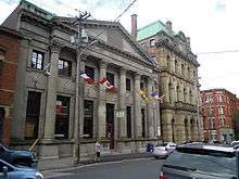
The Trinity Royal Heritage Conservation Area is a historic district in Saint John, New Brunswick's uptown. The City of Saint John designated the area as the city's first heritage conservation area in 1982; it has since expanded in area.[1] Surrounding the Trinity Anglican Church, the area includes several National Historic Sites of Canada within its boundaries. Much of the area consists of Victorian brick buildings raised after The Great Fire of Saint John, New Brunswick that destroyed much of the city's central peninsula in 1877.
Area

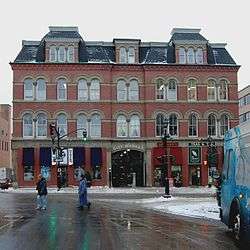
The Trinity Royal Heritage Conservation Area has more than a dozen blocks, relatively small, containing late Victorian buildings that house shops, restaurants, pubs, art galleries, other businesses, and private homes.
It is bounded by King Street, Water Street (beside a cruise ship terminal), Queen Street, Charlotte Street, and includes the adjacent Sydney Street and part of Union Street. Within these boundaries, it includes the following streets: Prince William, Canterbury, Germain, Queen Square North and Queen Square South, Princess, Duke, Harding, and Horsefield, as well as Grannan's Lane.
Although the nearby streets also include a large number of late Victorian buildings, the Trinity Royal area was the focus of conservation efforts as it contains many ornate brick commercial buildings, historic churches, and other public buildings such as the Saint John City Market.
National Historic Sites of Canada
The area includes the following designated National Historic Sites of Canada:
- Saint John City Market
- Bank of New Brunswick Building
- St. John's Anglican Church / Stone Church
- Trinity Anglican Church
- Imperial Theatre
- Saint John County Courthouse
- Number 2 Mechanics' Volunteer Company Engine House
- Prince William Streetscape
Other historic sites are within walking distance, such as Loyalist House, 1 Chipman Hill, the Loyalist Burial Ground, and King's Square.
Also nearby are Saint John City Hall, the New Brunswick Museum, Barbour's General Store, Market Square, and Brunswick Square.
See also
External links
References
- ↑ "Saint John Heritage Conservation Areas By-Law" (PDF). City of Saint John. Retrieved August 17, 2012.