Trimley railway station
| Trimley | |
|---|---|
 | |
| Location | |
| Place | Trimley St. Mary |
| Local authority | Suffolk Coastal |
| Grid reference | TM280361 |
| Operations | |
| Station code | TRM |
| Managed by | Greater Anglia |
| Number of platforms | 1 |
| DfT category | F2 |
|
Live arrivals/departures, station information and onward connections from National Rail Enquiries | |
| Annual rail passenger usage* | |
| 2012/13 |
|
| 2013/14 |
|
| 2014/15 |
|
| 2015/16 |
|
| 2016/17 |
|
| History | |
| Key dates | Opened 1891 |
| National Rail – UK railway stations | |
| * Annual estimated passenger usage based on sales of tickets in stated financial year(s) which end or originate at Trimley from Office of Rail and Road statistics. Methodology may vary year on year. | |
|
| |
Trimley railway station is on the Felixstowe Branch Line in the east of England, serving the village of Trimley St. Mary, Suffolk. It is 14 miles 5 chains (22.6 km) down the line from Ipswich and 82 miles 64 chains (133.3 km) measured from London Liverpool Street; it is situated between Derby Road and Felixstowe. Its three-letter station code is TRM.
It was opened by the Great Eastern Railway (GER) in 1891 and built to a design by the company's chief architect, W. N. Ashbee; it was one of only two stations outside Essex to be built in the New Essex, or Ashbee, style.[1] A branch line for goods trains to the port of Felixstowe was opened at Trimley in 1987.
Today it is managed by Greater Anglia, which also operates all passenger trains that call.
History
The Felixstowe Railway and Pier Company opened their line from Westerfield to Felixstowe Pier 1 May 1877 but the nearest station, other than at the pier near Landguard Common, was 'Orwell' at Nacton; a station at Felixstowe Beach was soon added but this was on the far side of the town so of little use to people in the Trimleys.[2] On 1 May 1891 that the station at Trimley was opened, by which time the railway had been purchased by the GER and trains were running through from Ipswich where connections were better than at Westerfield. In 1898 a new Felixstowe Town was opened which was more convenient for people travelling to the town.[3]
Public freight facilities were withdrawn on 13 July 1964, although they were retained at Felixstowe until 5 December 1966. In 1967 the branch was converted to "Pay Train" operation, with all fares being collected by the guard so that the only staff left at Trimley were the signalmen.[4]
A new direct line to Felixstowe docks was opened in 1970, with Felixstowe Beach Junction created between Trimley and Felixstowe. At the same time the signal box at Felixstowe was closed, the electric signals and new junction being operated from Trimley.[5]
Work on a new line from the east end of Trimley station to the Northern Freightliner Terminal at Felixstowe docks started in March 1986 and it was opened for traffic on 16 February 1987. It involved heavy earthworks and cost £2,000,000 but the dock owners received a 40% grant under Section 8 of the Railways Act 1974 as it would reduce road traffic.[6][7] As part of this work the signal box was closed and a modular building provided instead. This was west of the level crossing on the south side of the line.[8]
In 1997 this signal box was closed, control of the branch being transferred to Colchester Panel Signal Box. Colour light signals and motor-driven points are fitted throughout, while the level crossing is monitored by CCTV. A signal passed at danger (SPAD) indicator was installed on the platform to act as a warning to train drivers approaching from Felixstowe should they pass a red signal.[9]
Description

The railway to Felixstowe was built with just a single track, but when Trimley station was built a second track was laid to allow trains to pass in the station.[3] A platform was built for each track. The northern one (used by trains to Felixstowe) is nearer the village and so was provided with a single-storey building, also a small goods lock-up and a house for the station master. Two goods sidings were laid behind this platform. The southern platform (for trains to Ipswich) was provided with a waiting room and the signal box was built here, at the eastern end opposite the points for the goods sidings. People reach the station from the village along Cordy's Lane, which has a level crossing over the railway at the west end of the platforms.[10][11]
The loop was severed at the eastern end in 1987 in order to provide a connection to the new line to Felixstowe North Freightliner Terminal. Because of this the westbound platform was taken out of use and passenger trains in both directions now use the northern platform.[7]
Services
As of December 2016, the typical Monday-Saturday off-peak service at Trimley is one train per hour in each direction between Ipswich and Felixstowe.
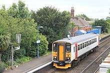
Trains are operated by Greater Anglia, and typically formed by Class 153 rolling stock.[12]
Proposed developments
In 2008 the Secretary of State for Transport approved the 'Felixstowe Branch Line and Ipswich Yard Improvement Order'. This empowered the laying of a second track for 7,150 metres (4.44 mi) from Trimley westwards to Levington. Crossovers at Trimley will allow two trains to pass on this section, and it will considerably shorten the single track section eastwards from Derby Road. This will help accommodate additional trains generated by the port's expansion and is one of a number of enhancements between Felixstowe and Nuneaton which are designed to allow trains to reach the West Coast Main Line without travelling over congested lines in the London area.[13]
In 2009 Network Rail proposed to demolish the empty station building. A 'Friends of Trimley Station' group was formed and Network Rail agreed that they would leave it standing if a viable use was found for it. Suffolk Coastal District Council asked the local residents and found that there was a demand for a community meeting place and an internet café.[14] In 2011 Network Rail offered the Friends a two-year lease to allow them time to waterproof the building and secure the funding necessary to create a meeting room and café. If successful they would then grant a long-term lease.[15] By the end of the year the Friends had succeeded in establishing a limited company, Trimley Station Community Trust, to take on the lease.[16]
References
- ↑ Trimley Station Community Trust: History, accessed 31 August 2015
- ↑ Quayle, H.I.; Bradbury, G.T. (1978). The Felixstowe Railway. Blanford Forum: The Oakwood Press. pp. 5–9.
- 1 2 Quayle & Bradbury 1978, p. 12
- ↑ Quayle & Bradbury 1978, pp. 34–37
- ↑ Quayle & Bradbury 1978, pp. 38–40
- ↑ "Trimley cut-off gets go-ahead". Modern Railways. Ian Allan. 43 (451): 183. April 1986. ISSN 0026-8356.
- 1 2 Peacock, Thomas B. (August 1987). "Felixstowe Postscript". Modern Railways. Ian Allan. 44 (467): 422. ISSN 0026-8356.
- ↑ Wallus, Andy T. (2012). Ipswich to Felixstowe Branch Through Time. Stroud: Amberley Publishing. p. 60. ISBN 978-1-4456-0766-5.
- ↑ Abbott, James (April 1999). "Rail Freight". Modern Railways. Ian Allan. 56 (607): 244–248. ISSN 0026-8356.
- ↑ Quayle & Bradbury 1978, p. 44
- ↑ Adderson, Richard; Kenworthy, Graham (2003). Branch Lines to Felixstowe and Aldeburgh. Midhurst: Middleton Press. Figs. 21–26. ISBN 978-1-904474-20-3.
- ↑ "Lowestoft and Felixstowe to Ipswich" (PDF). Greater Anglia. December 2016. Retrieved 2017-04-30.
- ↑ "Scheduled Works". The Felixstowe Branch Line and Ipswich Yard Improvement Order 2008. Department for Transport. 2008-10-14. Retrieved 2012-09-04.
- ↑ McGonagle, Katie (2010-10-21). "Light at the end of tunnel for historic station". Ipswich Star. Retrieved 2012-09-07.
- ↑ "Community on track to save historic station". Suffolk Coastal District Council. 31 August 2011. Archived from the original on 3 December 2013. Retrieved 7 September 2012.
- ↑ "Volunteers set up company to save Trimley station". Suffolk Coastal District Council. 2011-12-21. Retrieved 2012-09-07.
External links
| Wikimedia Commons has media related to Trimley railway station. |
| Greater Anglia | ||||
| Historical route | ||||
| Great Eastern Railway | ||||