Tree of Life (Bahrain)
| Tree of Life | |
|---|---|
 Tree of Life | |
| Shajarat-al-Hayat | |
| Species | Prosopis cineraria () |

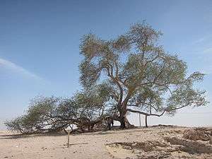
The Tree of Life (Shajarat-al-Hayat) in Bahrain is a 9.75 meters (32 feet) high Prosopis cineraria tree that is over 400 years old. It is on a hill in a barren area of the Arabian Desert, 2 kilometers (1.2 miles) from Jebel Dukhan, the highest point in Bahrain, and 40 kilometers from Manama, the nearest city.[1]
The tree is abundantly covered in green leaves. Due to its age and the fact that it is the only major tree growing in the area, the tree is a local tourist attraction and is visited by approximately 50,000 people every year. The yellow resin is used to make candles, aromatics and gum; the beans are processed into meal, jam, and wine.[2]
It is not certain how the tree survives. Bahrain has little to no rain throughout the year. Its roots are 50 meters deep which may be enough to reach the water source.[2] Others say the tree has learned to extract moisture from grains of sand. Some assert that the tree is protected by Enki, a god of water in Babylonian and Sumerian religion. Others claim that the tree is standing in what was once the Garden of Eden, and so has a more mystical source of water.[3]
In 2009, the tree was nominated to be on the New7Wonders of Nature list, but it did not finish on the list.[4]
In October 2010, archaeologists unearthed 500-year-old pottery and other artifacts in the vicinity of the tree. A soil and dendrochronology analysis conducted in the 1990s concluded that the tree was an Acacia planted in 1582.[5]
The tree was mentioned in the 1991 film L.A. Story, where Steve Martin calls it one of the most mystical places on earth.[2]
References
- ↑ "Tree of Life". Lonely Planet.
- 1 2 3 "The mysterious Tree of Life". KLM.
- ↑ "Tree of Life". Atlas Obscura.
- ↑ Toumi, Habib (May 16, 2009). "Bahrain's Tree of Life ranks high on Seven Wonders list". Gulf News.
- ↑ "Amphitheatre plan for Tree of Life". Trade Arabia. Manama. April 7, 2013.
Coordinates: 25°59′39″N 50°35′00″E / 25.994073°N 50.583235°E