Traunkirchen
| Traunkirchen | ||
|---|---|---|
 | ||
| ||
 Traunkirchen Location within Austria | ||
| Coordinates: 47°50′45″N 13°47′39″E / 47.84583°N 13.79417°ECoordinates: 47°50′45″N 13°47′39″E / 47.84583°N 13.79417°E | ||
| Country | Austria | |
| State | Upper Austria | |
| District | Gmunden | |
| Government | ||
| • Mayor | Christoph Schragl (ÖVP) | |
| Area | ||
| • Total | 18.3 km2 (7.1 sq mi) | |
| Elevation | 422 m (1,385 ft) | |
| Population (14 June 2016)[1] | ||
| • Total | 1,624 | |
| • Density | 89/km2 (230/sq mi) | |
| Time zone | UTC+1 (CET) | |
| • Summer (DST) | UTC+2 (CEST) | |
| Postal code | 4801 | |
| Area code | 07617 | |
| Vehicle registration | GM | |
| Website | www.traunkirchen.at | |

Traunkirchen is a municipality on the Traunsee in the Austrian state of Upper Austria, Austria.
Tourism
The lake and the mountains provide opportunities for outdoor activities like hiking, sailing, diving, skiing, swimming, and surfing. The village is known for the Fischerkanzel (Fisherman's Pulpit), located in the parish church, which was carved in 1753.
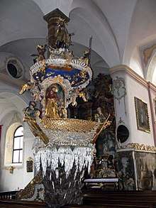
Fischerkanzel
Population
| Historical population | ||
|---|---|---|
| Year | Pop. | ±% |
| 1991 | 1,742 | — |
| 2001 | 1,745 | +0.2% |
| 2004 | 1,761 | +0.9% |
| 2014 | 1,621 | −8.0% |
| 2016 | 1,623 | +0.1% |
References
| Wikimedia Commons has media related to Traunkirchen. |
Places adjacent to Traunkirchen | ||||||||||
|---|---|---|---|---|---|---|---|---|---|---|
| ||||||||||
This article is issued from
Wikipedia.
The text is licensed under Creative Commons - Attribution - Sharealike.
Additional terms may apply for the media files.