Trashigang
Trashigang | |
|---|---|
 Main street, Tashigang, Bhutan | |
 Trashigang Location in Bhutan | |
| Coordinates: 27°19′57.2″N 91°33′09.9″E / 27.332556°N 91.552750°E | |
| Country |
|
| District | Trashigang District |
| Population (2005) | |
| • Total | 2,383 |
| Time zone | UTC+6 (BTT) |
Trashigang (Dzongkha: བཀྲ་ཤིས་སྒང་།), or Tashigang, is a town in eastern Bhutan and the district capital of the Trashigang Dzongkhag (district).
The town lies to the east side of the valley above the Drangme Chhu river just south of where it is joined by the Gamri River. Trashigang is the eastern terminus of the Lateral Road, Bhutan's main highway leading to Phuntsholing in the southwest.
The population of Trashigang was estimated to about 3000 in according to the 2005 census.[1]
In October 2011, Trashigang Dzong, under renovation since 2007, was on the verge of collapse. The dzong was built in 1659 by Trongsa Penlop Minjur Tenpa and served for centuries as an administrative headquarters and monastery, though government offices mostly relocated by 2011. Its sinking eastern foundation and crumbling upper walls necessitated either relocation or total destruction and reconstruction, according to dzongkhag officials.[2] However, as of 2012, the Trashigang Dzong was still used for the town's yearly tsechu.[3]
Trashigang is the largest district in Bhutan.It has three sub-districts and fifteen gewogs. Sherubtse College was the first accredited college in Bhutan, founded in 1966 by a group of Jesuits under the leadership of William Mackey. As of 2003 it became part of the newly created Royal University of Bhutan system that comprises all public post-secondary schools in Bhutan.
Trashigang is served by Yonphula Airport.
Rangjung, Kanglung and Wamrong are some of the major towns under Trashigang district.
Gallery
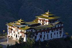 Trashigang Dzong (2011)
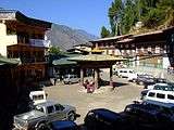 Town center, Trashigang, Bhutan (2008)
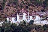 District court, Tashigang, Bhutan
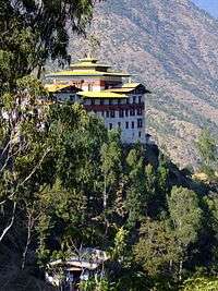 Trashigang Dzong (2008)
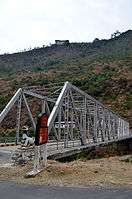 Trashigang Chagzam bridge
References
- ↑ "Bhutan: largest cities and towns and statistics of their population". World Gazetteer. Archived from the original on 2011-08-27. Retrieved 2008-07-11.
- ↑ Rinzin, Yangchen C (2011-10-29). "A Fortress That's About to Fall". Kuensel online. Retrieved 2011-10-29.
- ↑ "Tourism Council of Bhutan - Festival Dates 2012" (PDF). Tourism Council of Bhutan online. Retrieved 2012-12-17.
External links
| Wikimedia Commons has media related to Trashigang (town). |

- Trashigang and Dzong, Bhutan - Photo Gallery | The India Info
Coordinates: 27°20′N 91°34′E / 27.333°N 91.567°E