Trams in Stockholm
| Stockholm tramway network | |||||||||||||||
|---|---|---|---|---|---|---|---|---|---|---|---|---|---|---|---|
 Old and new tram on Tvärbanan, 2010. | |||||||||||||||
| Operation | |||||||||||||||
| Locale | Stockholm, Sweden | ||||||||||||||
| Status | Operational | ||||||||||||||
| Routes |
4 regular 1 heritage line | ||||||||||||||
| Owner(s) | Storstockholms Lokaltrafik (Stockholm County Council) | ||||||||||||||
| Operator(s) |
AB Stockholms Spårvägar (lines 7, 7N & 21) Arriva (lines 12 & 22) | ||||||||||||||
| Infrastructure | |||||||||||||||
| Track gauge | Standard (1,435 mm or 4 ft 8 1⁄2 in) | ||||||||||||||
| Minimum curve radius |
17.5 m (57 ft) (7, 7N) 25 m (82 ft) (12, 22) | ||||||||||||||
| Propulsion system(s) | Electricity | ||||||||||||||
| Electrification | 750 V DC overhead line | ||||||||||||||
| Stock | 194 | ||||||||||||||
| |||||||||||||||
| |||||||||||||||
| |||||||||||||||
| Website | AB Storstockholms Lokaltrafik (in English) | ||||||||||||||
The Stockholm tramway network forms part of the public transport system in Stockholm, the capital city of Sweden.
Beginning with horse trams in 1877, the Stockholm tram network reached its largest extent in 1946. Many of the former suburban tram lines became parts of the Stockholm Metro between the years 1950-1964. In September 1967, in conjunction with the Swedish switch from left-hand to right-hand traffic, the last parts of the once large inner-city street running tram network were closed. What little remained of the former network following 1967 were isolated suburban feeder lines to the Metro.
However; In 1991 a 3 km (1.9 mi) long heritage line opened to the recreational area Djurgården; and in 2000, the non-radial half-circle line Tvärbanan opened with articulated low-floor vehicles connecting an inner ring of Metro and commuter rail stations just outside the inner city proper, with subsequent extensions in 2003 and 2014; and in 2010 the heritage line was extended and converted to a regular service line.
History
The first tramway in Stockholm was opened in 1877 and was drawn by horses. A tramline run on steam-power opened in 1887. Stockholm's tram network was converted to electrical propulsion 1901-1905. An extensive network formed in the early 20th Century. Trams were effectively replaced by the Stockholm Metro from 1950 onwards, and all tram lines were closed down by 1967 due to the effect of Dagen H and replaced with buses (especially those in Stockholm proper), with the exception of two suburban tram lines, Lidingöbanan and Nockebybanan.
In 1991, one tram line, Djurgårdslinjen, was reopened as a heritage and tourist line. Since 2000, two more tram lines have been built from scratch, one to the suburb of Tvärbanan (Line 22), and one to the inner city Spårväg City (Line 7). The Tvärbanan tramline was extended in 2013, and will be further extended in the future.
Current service
As of 2018, the following lines provide service in the Stockholm metropolitan area:
| Line | Name | Length | Stations | Route | Type |
|---|---|---|---|---|---|
| 7 | Spårväg City | 3.5 km (2.2 mi) | 11 | T-Centralen – Waldemarsudde/Bellmansro | Tram |
| 7N | Djurgårdslinjen | 2.9 km (1.8 mi) | 10 | Norrmalmstorg – Waldemarsudde/Bellmansro | Heritage tramline |
| 12 | Nockebybanan | 5.6 km (3.5 mi) | 10 | Nockeby – Alvik | Light rail |
| 21 | Lidingöbanan | 9.2 km (5.7 mi) | 14 | Ropsten – Gåshaga brygga | Light rail |
| 22 | Tvärbanan | 18.2 km (11.3 mi) | 25 | Solna station – Sickla | Light rail |
All tramlines run on standard gauge track and use the same overhead voltage, 750 V DC. But there are two different cab signalling systems, one for Lidingöbanan, one for Tvärbanan. This makes rolling stock incompatible. The other tramlines (Nockeby and City/Djurgården) have no cab signalling requirement.
Gallery
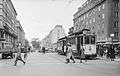 Line 14 (1931) on Sveavägen
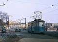 Line 2 (1963) near Stockholm City Hall
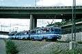 Older tram at Lidingöbanan (1996)
 Modern tram at Spårväg City (2011)
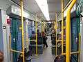 Interior of an A34 tram
References
See also
External links
![]()
- AB Storstockholms Lokaltrafik (in Swedish)
- AB Storstockholms Lokaltrafik (in English)
- 2012 Map of all SL Rail Lines (tram lines included) (pdf)
- Tram.se - Stockholm tramway lines (in English)
| Commuter rail |   | ||||
|---|---|---|---|---|---|
| Semi commuter rail |
| ||||
| Rapid transit | |||||
| Trams/Light rail | |||||
| Trolleybuses |
| ||||
| Ferries |
| ||||