Tornaľa
| Tornaľa | ||
| Tornalja | ||
| Town | ||
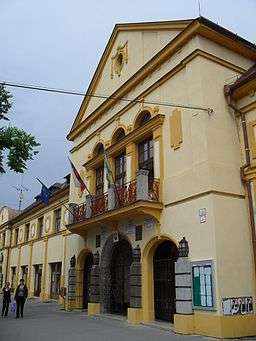 Town hall | ||
|
||
| Country | Slovakia | |
|---|---|---|
| Region | Banská Bystrica | |
| District | Revúca | |
| River | Slaná | |
| Elevation | 183 m (600 ft) | |
| Coordinates | 48°25′20″N 20°19′49″E / 48.42222°N 20.33028°ECoordinates: 48°25′20″N 20°19′49″E / 48.42222°N 20.33028°E | |
| Area | 57.768 km2 (22 sq mi) | |
| Population | 7,991 (2005-12-31) | |
| Density | 138/km2 (357/sq mi) | |
| First mentioned | 1245 | |
| Mayor | Anna Szögedi | |
| Timezone | CET (UTC+1) | |
| - summer (DST) | CEST (UTC+2) | |
| Postal code | 982 01 | |
| Phone prefix | 421-47 | |
| Car plate | RA | |
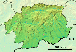 Location of Tornaľa in the Banská Bystrica Region  Tornaľa (Slovakia) | ||
| Wikimedia Commons: Tornaľa | ||
| Statistics: MOŠ/MIS | ||
| Website: http://www.mestotornala.sk | ||

Tornaľa (Slovak: Šafárikovo from 1948–1992; Hungarian: Tornalja) is a town and municipality in Revúca District in the Banská Bystrica Region of Slovakia, with a population of almost 8,000.
History
The first written record of Tornaľa dates from 1245. It was ruled by Ottoman Empire as part of Filek sanjak (Its centre was Rima Sonbot) during periods of 1554-1593 and 1596-1686. It was made part of Czechoslovakia, and remained as such except for a period of Hungarian rule between 1938 and 1945 due to the Vienna Awards.
Geography
Tornaľa lies at an altitude of 183 metres (600 ft) above sea level and covers an area of 57.768 square kilometres (22.3 sq mi).[1] It is located in the historical Gemer region and lies on the Slaná river.
Demographics
According to the 2001 census, the town had 8,169 inhabitants. 62.14% of inhabitants were Hungarians, 29.77% Slovaks, 6.70% Roma and 0.50% Czech.[1] The religious make-up was 49.37% Roman Catholics, 17.03% people with no religious affiliation and 7.33% Lutherans.[1]
References
- 1 2 3 "Municipal Statistics". Statistical Office of the Slovak republic. Archived from the original on 2008-01-11. Retrieved 2008-02-01.
External links
![]()
- Official website (in Slovak)