Tore (volcano)
| Tore | |
|---|---|
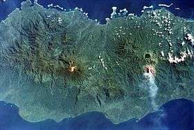 The Tore massif lies to the left of the light-colored area at the center of the image, Mount Balbi. | |
| Highest point | |
| Elevation | 2,200+ metres (7,218 feet) |
| Coordinates | 5°50′S 154°56′E / 5.83°S 154.93°E |
| Geography | |
| Parent range | Emperor Range |
| Geology | |
| Mountain type | Caldera, lava cone |
| Last eruption | Unknown |
Tore is a volcano located in the northern part of the island of Bougainville, Papua New Guinea. Violent Pleistocene eruptions produced two ignimbrite fans stretching west to the coast, and a 6 km by 9 km caldera. A post-caldera lava cone on the caldera's southern rim is the source of lava flows. Well-preserved features suggests a recent date for this cone and a nearby ash cone.
See also
References
This article is issued from
Wikipedia.
The text is licensed under Creative Commons - Attribution - Sharealike.
Additional terms may apply for the media files.