Tonoshō, Kagawa
| Tonoshō 土庄町 | |||
|---|---|---|---|
| Town | |||
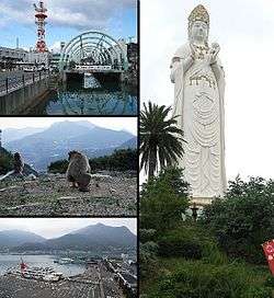 Clockwise from top left:Dofuchi Strait, Big Kannon statue in Bushi Temple, Tonoshō Port, Chōshi Gorge | |||
| |||
 Location of Tonoshō in Kagawa Prefecture | |||
 Tonoshō Location in Japan | |||
| Coordinates: 34°29′N 134°11′E / 34.483°N 134.183°ECoordinates: 34°29′N 134°11′E / 34.483°N 134.183°E | |||
| Country | Japan | ||
| Region | Shikoku | ||
| Prefecture | Kagawa Prefecture | ||
| District | Shōzu | ||
| Government | |||
| • Mayor | Kōhei Okada | ||
| Area | |||
| • Total | 74.38 km2 (28.72 sq mi) | ||
| Population (February 1, 2012) | |||
| • Total | 14,810 | ||
| • Density | 199.11/km2 (515.7/sq mi) | ||
| Symbols | |||
| • Tree | Ubamegashi (Quercus phillyraeoides) | ||
| • Flower | Azalea | ||
| Time zone | UTC+9 (JST) | ||
| City hall address |
559-2 Kō, Tonoshō-chō, Shōzu-gun, Kagawa-ken 761-4192 | ||
| Website |
www | ||

Tonoshō (土庄町 Tonoshō-chō) is a town located in Shōzu District, Kagawa Prefecture, Japan. It is located on the island of Shōdoshima in the Inland Sea. Small islands on the Inland Sea, including Teshima, belong to its administrative area.
As of February 1, 2012, the town has an estimated population of 14,810 with 6,222 households, and a population density of 199.11 persons per km². The total area is 74.38 km².
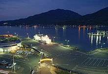
Tonoshō port at night
External links
- Official website (in Japanese)
| Core city | ||
|---|---|---|
| Cities | ||
| Districts | ||
This article is issued from
Wikipedia.
The text is licensed under Creative Commons - Attribution - Sharealike.
Additional terms may apply for the media files.