Tonnerre River (Minganie)
| Tonnerre | |
| River | |
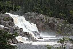 Waterfall "Grand Sault" on "Tonnerre River" | |
| Country | Canada |
|---|---|
| Province | Quebec |
| Region | Côte-Nord |
| Tributaries | |
| - left | Outlet of "lac Queue-de-Chat" and the "Lacs aux Erratiques". |
| Source | Unidentified Lake |
| - location | MRC Minganie Regional County Municipality, Côte-Nord, Quebec |
| - elevation | 484 m (1,588 ft) |
| - coordinates | 49°26′13″N 74°03′34″W / 49.43694°N 74.05944°W |
| Mouth | Gulf of Saint Lawrence |
| - location | Rivière-au-Tonnerre, Quebec, MRC Minganie Regional County Municipality, Côte-Nord, Quebec |
| - elevation | 0 m (0 ft) |
| - coordinates | 50°16′25″N 64°46′46″W / 50.27361°N 64.77944°WCoordinates: 50°16′25″N 64°46′46″W / 50.27361°N 64.77944°W |
| Length | 85 km (53 mi) [1] |
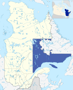 Administrative region of Côte-Nord in relation to Quebec. | |
The rivière au Tonnerre (English: Thunder River) is a watercourse that runs through the municipality of Rivière-au-Tonnerre, Quebec in the Minganie Regional County Municipality (RCM), in the Côte-Nord administrative region, in Quebec, in Canada.
The course of the river crosses the township of Margane, then constitutes the boundary between the townships of Margane and Touzel until the confluence of the river with the North shore of the Gulf of Saint Lawrence.
The southern portion of the "Tonnerre River" hydrographic slope is served by route 138 along the north shore of the Gulf of Saint Lawrence. The R0902 forest road (going north-west) serves the western part of this slope.
The surface of the "Thunder River" is usually frozen from early November to the end of April, however, safe ice circulation is generally from late November to mid-April.
Geography
The upper course of the "Tonnerre River" has many rapids because of the steep mountain slope. The river has its source in a mountainous area, located 6 kilometres (3.7 mi) west of Lake Magpie. The river runs southward on 85 kilometres (53 mi). The river flows west of the Magpie River (Quebec) watershed and east of the Sheldrake River.
Going down to the south, this stream crosses the north-shore municipality of Rivière-au-Tonnerre, Quebec, before pouring into the Gulf of St. Lawrence in Kennedy Cove, 2.5 kilometres (1.6 mi) west of “Pointe au Tonnerre”. The municipality of Rivière-au-Tonnerre, Quebec is located midway between Havre-Saint-Pierre and Sept-Îles.
Themouth of this river includes a narrow channel used by boat drivers to enter the harbor to take refuge in case of strong waves.
Toponymy
At 5 kilometres (3.1 mi) upstream of the mouth, the river crosses “Chute au Tonnerre” (English: Thunderfall), which is about 30 metres (98 ft) high. The sound of the waterfall evokes the sound of lightning during electrical storms; which would explain the origin of the place name.
On maps of Bellin (1744) and Vaugondy (1755), the Tonnerre River is mentioned using its Amerindian name, Ouchigouchipi. On a map of 1776, Captain Carver, indicates the name "Ouchigoush-ipi".
The Uhukuhîpu variant has also been used, thanks to anthropological research. The Montagnais designate this river U`suk `Sipo. Although the graphy varies according to the period and the authors of geographical maps, the meaning of this toponym of origin Montagnais is "river with the beaks-saw". This designation refers to the red-breasted bill-saw (Mergus serrator), a bird species widely distributed on the North Shore.
Curiously, the spelling "Sheldrake", designating the neighboring watercourse, located immediately to the west of the Tonnerre River, is the English equivalent of the word "saw-bill". The map of Bouchette fils (1853) mentions "Thunder R.". The maps of Taché (1870 and 1880) mention "R. au Tonnerre ».[2]
The toponym "Rivière au Tonnerre" was formalized on December 5, 1968, at the Bank of Place Names of the Commission de toponymie du Quebec.[3]
Notes and references
- ↑ "Atlas of Canada". atlas.nrcan.gc.ca. Retrieved 2018-02-16.
- ↑ Work: Names and Places in Quebec, a work of the Commission de toponymie du Québec, published in 1994 and 1996 in the form of a printed illustrated dictionary, and under a CD-ROM produced by the company Micro -Intel, in 1997, from this dictionary.
- ↑ Commission de toponymie du Quebec - Bank of Place Names - Toponym: Rivière au Tonnerre.
See also
Related Articles
- Rivière-au-Tonnerre, Quebec,
- Minganie Regional County Municipality (RCM)
- Côte-Nord, administrative region
- List of rivers of Quebec