Tobacco Caye
Coordinates: 16°53′54″N 88°3′43″W / 16.89833°N 88.06194°W
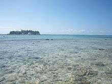
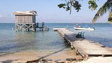
Tobacco Caye is a tiny island in Belize, about 10 miles (16 kilometres) east of Dangriga. It is approximately three acres (1.2 hectares) in area, shaped like an egg, with a north-south dimension of about 240 m (260 yd) and an east-west dimension of 125 metres (137 yards). It has a permanent population of about 20, and sees a regular stream of travelers thanks to the four small lodges on the island.[1][2] The island is believed to have been named for the early cultivation of tobacco there.[3] The earliest known European chart to indicate Tobacco Caye was by the British geographer J. Speer in 1771.[4]
Tobacco Caye lies within the South Water Caye Marine Reserve, part of Belize's national system of protected waters, with a range of restrictions on fishing.
The island was ravaged by Hurricane Mitch in 1998 but has since been rebuilt.
External links
| Wikivoyage has a travel guide for Tobacco Caye. |
| Wikimedia Commons has media related to Tobacco Caye. |
References
- ↑ About.com posting Archived 2012-03-21 at the Wayback Machine.
- ↑ Moon guide article
- ↑ Stoddart, D.R. (1982). Cays of the Belize Barrier Reef and Lagoons. Washington, DC: Smithsonian Institution.
- ↑ Speer, J. (1771). The West-India Pilot. London. p. 15.