Tjørnholstind
| Tjørnholstind | |
|---|---|
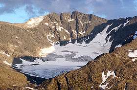 Tjørnholstind (right highest peak) seen from the north. | |
| Highest point | |
| Elevation | 2,331 m (7,648 ft) |
| Prominence | 340 m (1,120 ft) [1] |
| Listing | 17 at List of mountains in Norway by height |
| Coordinates | 61°27′8″N 8°39′17″E / 61.45222°N 8.65472°ECoordinates: 61°27′8″N 8°39′17″E / 61.45222°N 8.65472°E |
| Geography | |
| Location | Vågå, Oppland, Norway |
| Parent range | Jotunheimen |
| Topo map | 1617 IV Gjende |
| Climbing | |
| First ascent | July 28, 1843: Harald Nicolai Storm Wergeland |
Tjørnholstind (official form on maps: Tjønnholstinden) is a mountain in Vågå, Oppland, Norway and lies in the mountain range Jotunheimen south of the lake Gjende and north of the valley Leirungsdalen. On the northern side is a 400 m vertical drop down to Nordre Tjønnholet, a glacier.
The mountain has two peaks with a narrow ridge between. The western summit is the highest and the lower eastern summit also has the name Steinflytind and has elevation 2,318 m (7,605 ft).
The mountain and both peaks are easily accessible from both west and east.
The name
The first element is the genitive of the name of the gorge Tjønnholet, the last element is the finite form of tind m 'mountain peak'. The name of the gorge is a compound of tjønn f 'tarn, small lake' and the finite form of hol n 'hole (hollow), gorge'. There are actually two gorges with the name Tjønnholet here: Nørdre Tjønnholet north of the peak - and Søre Tjønnholet south of the peak.
References