Three V Crossing, North Dakota
| Three V Crossing, North Dakota | |
|---|---|
| Unincorporated community | |
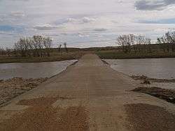 The crossing on the Little Missouri River | |
 Three V Crossing, North Dakota  Three V Crossing, North Dakota | |
| Coordinates: 46°33′25″N 103°47′31″W / 46.55694°N 103.79194°WCoordinates: 46°33′25″N 103°47′31″W / 46.55694°N 103.79194°W | |
| Country | United States |
| State | North Dakota |
| County | Slope |
| Elevation | 2,526 ft (770 m) |
| Time zone | UTC-7 (Mountain (MST)) |
| • Summer (DST) | UTC-6 (MDT) |
| Area code(s) | 701 |
| GNIS feature ID | 1035208[1] |
Three V Crossing is an unincorporated community in Slope County, North Dakota, United States. Three V Crossing is located on the Little Missouri River 19.1 miles (30.7 km) north-northeast of Marmarth.
References
Municipalities and communities of Slope County, North Dakota, United States | ||
|---|---|---|
| Cities | 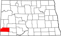 | |
| Unincorporated communities | ||
This article is issued from
Wikipedia.
The text is licensed under Creative Commons - Attribution - Sharealike.
Additional terms may apply for the media files.