Thousand Islands Border Crossing
| Thousand Islands Border Crossing | |
|---|---|
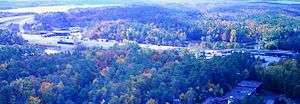 Thousand Islands Border Crossing, as seen in 2003 from the 1000 Islands Tower. The US border station is on the left. | |
| Location | |
| Country | United States; Canada |
| Location |
US Port: 46735 Interstate Route 81, Alexandria Bay, New York 13607 Canadian Port: 860 Highway 137, Lansdowne, Ontario K0E 1L0 |
| Coordinates | 44°20′50″N 75°59′00″W / 44.347318°N 75.983396°W |
| Details | |
| Opened | 1938 |
| Hours | Open 24 hours |
|
Website www www | |
The Thousand Islands Border Crossing connects the towns of Alexandria Bay, New York and Ivy Lea, Ontario on the Canada–US border. The crossing is via the international span of the Thousand Islands Bridge. The Thousand Islands bridge, which was completed in 1938, is actually a system of three bridges and the island roadways connecting them. The international span, which crosses a small rift between Wellesley Island in the US and Hill Island in Canada, is only 90 feet (27 m) in length. A second, parallel span was built in 1959 to accommodate congestion at the ports of entry.[1] The US and Canada border stations are located at the opposite ends of this span.
The crossing is the westernmost of the three on the St. Lawrence River and is very busy, with up to two hours of waits during the summer.[2] The US border station of Alexandria Bay has sometimes been called "Thousand Islands", and the Canada border station of Lansdowne has sometimes been called "Gananoque", named for the nearby town where international ferry service has historically (and continues to be) provided. These border stations are also responsible for inspecting vessel traffic between the two countries. The US has seasonal vessel inspection stations on Heart Island and at Cape Vincent, NY, and Canada has seasonal vessel inspection stations at Rockport, Ontario and Gananoque, Ontario, and both Canada Border Services Agency (CBSA) and the U.S. Customs and Border Protection (CBP) will travel to selected ports and marinas to conduct inspections upon request.
See also
References
- ↑ "Our History". Thousand Islands Bridge Authority. Retrieved 14 February 2016.
- ↑ "Chapter 4: The Watery Boundary". United Divide: A Linear Portrait of the USA/Canada Border. The Center for Land Use Interpretation. Winter 2015.