Thouria, Messenia
| Thouria Θουρία | |
|---|---|
.jpg) Stone house covered with Boston ivy in Thouria | |
 Thouria Location within the regional unit 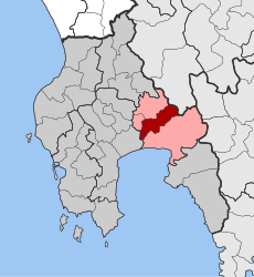 | |
| Coordinates: 37°05′N 22°03′E / 37.083°N 22.050°ECoordinates: 37°05′N 22°03′E / 37.083°N 22.050°E | |
| Country | Greece |
| Administrative region | Peloponnese |
| Regional unit | Messenia |
| Municipality | Kalamata |
| • Municipal unit | 76.922 km2 (29.700 sq mi) |
| Population (2011)[1] | |
| • Municipal unit | 2,721 |
| • Municipal unit density | 35/km2 (92/sq mi) |
| Community[1] | |
| • Population | 884 (2011) |
| Time zone | UTC+2 (EET) |
| • Summer (DST) | UTC+3 (EEST) |
| Vehicle registration | ΚΜ |
Thouria (Greek: Θουρία) is a village and a former municipality in Messenia, Peloponnese, Greece. Since the 2011 local government reform it is part of the municipality Kalamata, of which it is a municipal unit.[2] The municipal unit has an area of 76.922 km2.[3] Its population in 2011 was 2,721.
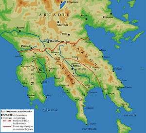
Thouria in ancient Greece, located west of Sparta.
References
- 1 2 "Απογραφή Πληθυσμού - Κατοικιών 2011. ΜΟΝΙΜΟΣ Πληθυσμός" (in Greek). Hellenic Statistical Authority.
- ↑ Kallikratis law Greece Ministry of Interior (in Greek)
- ↑ "Population & housing census 2001 (incl. area and average elevation)" (PDF) (in Greek). National Statistical Service of Greece.
This article is issued from
Wikipedia.
The text is licensed under Creative Commons - Attribution - Sharealike.
Additional terms may apply for the media files.