Thorpe Abbotts
| Thorpe Abbotts | |
|---|---|
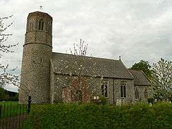 The parish church of All Saints, Thorpe Abbots, Norfolk | |
 Thorpe Abbotts Thorpe Abbotts shown within Norfolk | |
| Population | 605 (parish, 2001 census) |
| OS grid reference | TM190790 |
| • London | 106 miles (171 km) |
| Civil parish |
|
| District | |
| Shire county | |
| Region | |
| Country | England |
| Sovereign state | United Kingdom |
| Post town | DISS |
| Postcode district | IP21 |
| Dialling code | 01379 |
| Police | Norfolk |
| Fire | Norfolk |
| Ambulance | East of England |
| EU Parliament | East of England |
Thorpe Abbotts is a village within the civil parish of Brockdish (where the population is listed) in the English county of Norfolk.[1] The village is 6.5 miles (10.5 km) east of Diss, 20.8 miles (33.5 km) south south west of Norwich and 106 miles (171 km) north east of London. The village lies .4 miles (0.64 km) north of the A143 Diss to Great Yarmouth road.[2] The nearest railway station is at Diss for the Great Eastern Main Line which runs between Norwich and Liverpool Street station, London. The nearest airport is Norwich International Airport. The village, as part of the larger parish in the 2001 census, had a population of 605. For the purposes of local government, the parish falls within the district of South Norfolk.
History
Thorpe Abbotts has an entry in the Domesday Book of 1085.[3] In the great book, Thorpe Abbotts is recorded by the name Thorp and is said to be King’s land, in the charge of William de Noyers.
Station 139
During the Second World War, Thorpe Abbotts became home to RAF Station Thorpe Abbotts with the designation 139, Thorpe Abbotts.[4] The airfield was built in 1942 by John Laing & Sons Ltd. The airfield had three intersecting runways laid with concrete which were encircled by a three and a half mile perimeter road.[5] The perimeter road had hard standings for fifty aircraft. There were two hangars, a technical site and a domestic area. The station became operational in June 1943 when the 100th Bomb Group of the United States Army Air Forces took up residency equipped with the Boeing B-17 Flying Fortress. The group became known as the ‘’Bloody 100th’’ because of the heavy losses incurred by the group on a number of their combat missions.[6] The 100th were the only group to fly operations from Thorpe Abbots and during a period between 15 June 1943 and 10 April 1945, 306[7] missions were flown from the airfield. The USAAF left the station in December 1945 when the airfield was returned to the RAF and it remained inactive until April 1956 when the airfield was finally closed (de-requisitioned).
The land owned by Sir Rupert Mann has been returned to agricultural use but the perimeter road remained intact until 1986 when it was demolished. Some of the buildings including the control tower still survive. Today the old control tower has been fully restored and contains a museum dedicated to the famous 'Bloody Hundredth' Bomb Group.[8] The museum tells the story of Thorpe Abbotts and portrays every-day life on an American bomber base. A D-4 link trainer is on display, while a B-24 tail turret is undergoing restoration. Special events and reunions are frequently staged.
Eddie the Ghost
From time to time, visitors to the museum report an overpowering presence within the control tower, occasionally accompanied by the brief glimpse of an airman dressed in full flying gear.[9] The sound of VHF chatter and the sound of aircraft have also been heard. These strange apparitions are not a new phenomenon. "Eddie the Ghost", as American personnel nicknamed him, began to appear after the first Berlin raids in 1942; he was reported as walking through walls of the airmen’s quarters. Stories of the ghost persisted with some of the men taking their carbines to bed with them. Fearing an accident, Colonel Jeffrey, the station (base) commander, forbade all talk of Eddie on penalty of court martial. Today, sightings are less frequently recorded although Eddie is occasionally seen when the tower is locked at night. He appears at the first-floor window looking out as if to say good night.[9]
Gallery
 The restored control tower
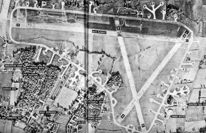 Thorpe Abbots Airfield - 13 November 1946
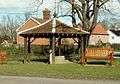 The Village Pump
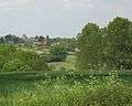 Thorpe Abbotts, with All Saints, from s. across Waveney valley
All Saints parish church
All Saints parish church is one of 124 existing round-tower churches in Norfolk. The church was almost entirely refurbished in the 19th century but still possess its medieval font and screen. The church is a Grade I listed building .
The village pump
The village hand pump was installed by Lord Justice Kay in 1867 and has a wooden canopy placed over it. The pump has undergone several restorations - in 1924 by a local doctor and, more recently, by the villagers in 1979.
References
- ↑ OS Explorer Map 230 – Diss & Harleston ISBN 0-319-23804-0
- ↑ County A to Z Atlas, Street & Road maps Norfolk, Page 232, ISBN 978-1-84348-614-5
- ↑ The Domesday Book, England's Heritage, Then and Now, Editor: Thomas Hinde,Norfolk page 195 ISBN 1-85833-440-3
- ↑ Airfields of the Eighth, Then and Now, By Roger A. Freeman/After the Battle Magazine: Published by Battle of Britain Prints International Ltd: ISBN 0-900913-09-6
- ↑ Aerial photo of RAF Thorpe Abbotts from Multimap.Com
- ↑ Airfields of the Eighth, Then and Now, By Roger A. Freeman/After the Battle Magazine: Published by Battle of Britain Prints International Ltd: Page 217 ISBN 0-900913-09-6
- ↑ The Mighty Eighth The Colour Record. Freeman, Roger A. (1991) Cassell & Co. ISBN 0-304-35708-1
- ↑ The Museum Web-site
- 1 2 Ghost Fields of East Anglia by Martin W Bowman, Page 114, Published by Halsgrove 2007 ISBN 978-1-84114-653-9
External links
| Wikimedia Commons has media related to Thorpe Abbotts. |
- Diss Express - village's local newspaper website
- Website with photos of Thorpe Abbotts All Saints, a round-tower church
- 100th Bomb Group website
- Thorpe Abbots photo gallery