Thixendale
| Thixendale | |
|---|---|
 Thixendale | |
 Thixendale Thixendale shown within North Yorkshire | |
| Population | 293 (Including Wharram-le-Street. 2011 census) |
| OS grid reference | SE840611 |
| District | |
| Shire county | |
| Region | |
| Country | England |
| Sovereign state | United Kingdom |
| Post town | MALTON |
| Postcode district | YO17 |
| Dialling code | 01377 |
| Police | North Yorkshire |
| Fire | North Yorkshire |
| Ambulance | Yorkshire |
| EU Parliament | Yorkshire and the Humber |
| UK Parliament |
|
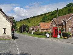
Thixendale is a civil parish in the Ryedale district of North Yorkshire, England. Historically part of the East Riding of Yorkshire, it is located in the Yorkshire Wolds about 20 miles east of York.
The place-name 'Thixendale' is first attested in the Domesday Book of 1086, where it appears as Sixtendale and Xistendale. The name means 'Sigstein's dale or valley'. The name 'Sigstein' is also the source for the name of Sysonby in Leicestershire.[1]
The population of the village and surrounding farms is 130, rising to 293 at the 2011 census.[2]
The only pub, the Cross Keys, is a regular winner of local CAMRA awards.
The Yorkshire Wolds Way National Trail, a long distance footpath passes to the east end of the village.
The church of St Mary, Thixendale is one of a group of village buildings constructed to designs by George Edmund Street in 1868–70. It was designated in 1966 by English Heritage as a Grade II* listed building.[3] It is on the Sykes Churches Trail devised by the East Yorkshire Historic Churches Group.[4]
For many years until the late 1990s, television signals were blocked by the surrounding hills until a small transmitter was built, providing the village with terrestrial television for the first time. The transmitter ceased operation in the early 2000s, with villagers now relying on satellite TV and, since 2017, fast broadband.
References
- ↑ Eilert Ekwall, The Concise Oxford Dictionary of English Place-names, p.466.
- ↑ "Parish population 2011". Neighbourhood Statistics. Office for National Statistics. Retrieved 13 August 2015.
- ↑ Historic England. "Church of Saint Mary (1316014)". National Heritage List for England. Retrieved 27 June 2013.
- ↑ "Sykes Churches Trail Southern Route". Beverley, East Yorkshire: East Yorkshire Historic Churches Group.
External links
| Wikimedia Commons has media related to Thixendale. |
- Thixendale in the Domesday Book
- The Village of Thixendale information about the village, where to stay, interesting walks in the area, pictures and other local information,
- A requiem to Thixendale's Youth Hostel