Third Hill Mountain
| Third Hill Mountain | |
|---|---|
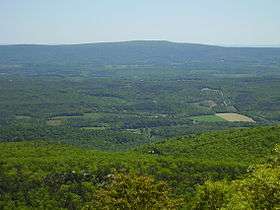 High Knob, the summit of Third Hill Mountain, as viewed from Cacapon Mountain | |
| Highest point | |
| Elevation | 2,165 ft (660 m) [1] |
| Prominence | 1,142 ft (348 m) [2] |
| Coordinates | 39°32′N 78°07′W / 39.53°N 78.11°WCoordinates: 39°32′N 78°07′W / 39.53°N 78.11°W[3] |
| Geography | |
 Third Hill Mountain Location of Third Hill Mountain in West Virginia | |
| Location | Berkeley County, West Virginia, U.S. |
| Parent range | Ridge-and-Valley Appalachians |
| Topo map | USGS Glengary |
Third Hill Mountain is both the highest and most topographically prominent mountain in Berkeley County within the Eastern Panhandle of West Virginia. Third Hill Mountain reaches its highest elevation of 2,165 feet (660 m) above sea-level southeast of the "Locks-of-the-Mountain" where it "locks" with Sleepy Creek Mountain. The long distance Tuscarora Trail passes along ridge and bench of the mountain.
Adjacent area
Together with Sleepy Creek Mountain, the two mountains contain between them Sleepy Creek Lake and the Sleepy Creek Wildlife Management Area. Sleepy Creek and Third Hill Mountains are distinctive for their height in the relatively level terrain of the far Eastern Panhandle region of West Virginia.
References
This article is issued from
Wikipedia.
The text is licensed under Creative Commons - Attribution - Sharealike.
Additional terms may apply for the media files.