Theresia Bastion
| Theresia Bastion | |
|---|---|
 Overview of the Bastion | |
| General information | |
| Town or city | Timișoara |
| Country | Romania |
| Construction started | 1732[1] |
| Completed | 1734[2] |
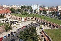
Theresia Bastion (Romanian: Bastionul Theresia), named after the Austrian Empress Maria Theresa, is the largest preserved piece of defensive wall of the Austrian-Hungarian fortress of Timișoara. It covers about 1.7 hectares of the city center. It was built between 1732–1734.[2][1] Today it is used as a passage, but it also houses commercial spaces, restaurants, bars, a disco and a library, and two permanent exhibitions of the Museum of Banat, the Information and Communications Technology "Violin - a passion for life", and the Ethnography Museum Village.[3][4] The bastion is included on the list of historical monuments in the Timiș County with classification code TM-II-m-A-06103.03.
History
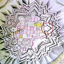
After the conquest of Timișoara by the Habsburgs in 1716, it was realized that the old fortifications could not cope with new fighting techniques, therefore it was decided to rebuild the whole city in Pagan style[5] (a fortress-stronghold of a stellar shape). It had an area larger than the Ottoman medieval fortress. The city was surrounded by three stellar belts that could be filled with water. Access was via three gates: of Vienna, Petrovaradin and Transylvania (completely demolished in 1891). The nine bastions of the fortress were named after kings and queens or generals. In the second half of the 19th century, the majority of the city walls was demolished to make room for the rapidly expanding city.[6]
See also
References
- 1 2 Opriș, Monografia, pp. 70–71
- 1 2 Opriș, Monografia, p. 38
- ↑ (in English)(in German)(in Romanian) Discovering Timisoara/Lernen wir Temeswar kennen/Să cunoaștem Timișoara, Ghid turistic, accesat 2016-12-09
- ↑ (in Romanian) Georgeta Petrovici, Bastionul Theresia devine "Grădina de vise", evz.ro, 12 octombrie 2010, accesat 2016-12-09
- ↑ Capotescu, pp. 58–59
- ↑ (in Romanian) Ciprian Glăvan, Defortificarea cetății Timișoarei, Timișoara: Analele Banatului, s.n., Arheologie – Istorie, XXI, 2013, accesat 2016-07-15
Literature
- (in Romanian) Mihai Opriș, Timișoara: Monografie urbanistică, vol. I: Descoperiri recente care au impus corectarea istoriei urbanistice a Timișoarei, Timișoara: Ed. BrumaR, 2007, ISBN 978-973-602-245-6
- (in Romanian) Valentin Capotescu, Arhitectura militară bastionară în România, vol. I: Cetatea Timișoarei, Timișoara: Ed. Bastion, 2008, ISBN 978-973-88780-1-3
| Historical |
|  |
|---|---|---|
| Cultural |
| |
| Places of worship | ||
| Educational | ||
| Statues and monuments |
| |
| Forests, parks, gardens and natural landmarks |
| |
| Squares |
| |
| Sports venues | ||
| Shopping |
| |
| Infrastructure | ||
Coordinates: 45°45′25″N 21°14′00″E / 45.75694°N 21.23333°E