Theodulhorn
| Theodulhorn | |
|---|---|
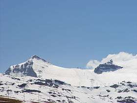 The Theodulhorn (left) from the north side | |
| Highest point | |
| Elevation | 3,469 m (11,381 ft) |
| Prominence | 120 m (390 ft) [1] |
| Parent peak | Furgggrat |
| Coordinates | 45°56′57.6″N 07°42′30.3″E / 45.949333°N 7.708417°ECoordinates: 45°56′57.6″N 07°42′30.3″E / 45.949333°N 7.708417°E |
| Geography | |
 Theodulhorn Location in the Alps | |
| Location |
Valais, Switzerland Aosta Valley, Italy |
| Parent range | Pennine Alps |
The Theodulhorn (3,469 m) is a mountain of the Pennine Alps, overlooking the Theodul Pass on the border between Switzerland and Italy. It lies south of Zermatt (in Valais) and east of Breuil-Cervinia (in the Aosta Valley). The northern side of the mountain is heavily glaciated and is part of a ski area.
The Theodulhorn is the easternmost summit of the range descending from the south-east ridge of Matterhorn, named Furgggrat. It is named for Theodul Pass, which is in turn named for Saint Theodul, patron saint of the Valais.
References
External links
| Wikimedia Commons has media related to Theodulhorn. |
This article is issued from
Wikipedia.
The text is licensed under Creative Commons - Attribution - Sharealike.
Additional terms may apply for the media files.