Sheepleas
The Sheepleas is a 108 hectares (270 acres) Nature Reserve and Site of Special Scientific Interest in the North Downs in Surrey, close to East and West Horsley.[1][2] It is managed by the Surrey Wildlife Trust.[3][4] It is also part of The Surrey Hills
.jpg)
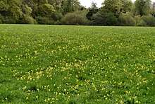
The Sheapleas was beech woodland until the Great Storm of 1987, when hurricane winds destroyed the majority of mature trees. Subsequently, the area has been a mixture of open grasslands and younger beech forest. The truly outstanding place has never been farmed or artificially fertilized, and is known to have been used for grazing sheep (from which it gets its name) since the majority of the peasant population was killed by the Black Death in the 14th century.[5][6]
It has two marked trails; a woodland trail and a grassland trail. There are three car parks. One is on Shere Road, one is on Green Dene, and the other is by St. Mary's Church, West Horsley.
References
- ↑ "Sheepleas". Local Nature Reserves. Natural England.
- ↑ "Map of Sheepleas". Local Nature Reserves. Natural England.
- ↑ 'Exploring Woodland: South East England' , Woodland Trust (ed. Graham Blight), ISBN 0-7112-2659-8
- ↑ Guildford Borough
- ↑ "Sheepleas | Surrey Wildlife Trust". www.surreywildlifetrust.org. Retrieved 2016-02-25.
- ↑ "West Horsley Parish Council | History of the village". www.westhorsley.info. Retrieved 2016-02-25.
External links
Coordinates: 51°15′10″N 0°26′23″W / 51.2528°N 0.4398°W