The Sanctuary
| UNESCO World Heritage site | |
|---|---|
 | |
| Location | Wiltshire, United Kingdom |
| Part of | Avebury Section of Stonehenge, Avebury and Associated Sites |
| Criteria | Cultural: (i), (ii), (iii) |
| Reference | 373bis-002 |
| Inscription | 1986 (10th Session) |
| Extensions | 2008 |
| Coordinates | 51°24′36″N 1°49′54″W / 51.41000°N 1.83173°WCoordinates: 51°24′36″N 1°49′54″W / 51.41000°N 1.83173°W |
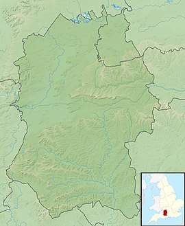 Location of The Sanctuary in Wiltshire | |
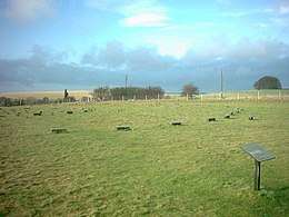
The Sanctuary is a prehistoric site on Overton Hill located around 5 miles west of Marlborough in the English county of Wiltshire. Four concentric rings of post holes, and two outer rings of standing stones were first noted in 1648, and were drawn by William Stukeley in 1723, shortly before it was largely destroyed by a local farmer.[1] Excavation in 1930 re-identified the location of the 58 stone sockets and 62 post-holes, the locations of which are now marked with concrete blocks.[2]
It is part of a wider Neolithic landscape which includes the nearby sites of Silbury Hill, West Kennet Long Barrow and Avebury, to which The Sanctuary was linked by the 25m wide and 2.5 km long Kennet Avenue. It also lies close to the route of the prehistoric Ridgeway and near several Bronze Age barrows. It lies within the area of the Avebury section of the Stonehenge, Avebury and Associated Sites World Heritage Site.[3]
Phases of Construction
The first stage of activity at the site, some time around 3000 BC, consisted of a ring of eight wooden posts 4.5 metres (15 ft) across, with a central post, presumed to be a round hut.[2] Within 200 years the first ring was enlarged to 6m and a second ring was added, also of eight posts, but this time 11.2 metres (37 ft), perhaps creating a large hut or an enclosure.[4] Phase three, some time in the later Neolthic, a third ring of 33 posts were added, in a circle 21 metres (69 ft) across, and at the same time an inner stone circle of 15 or 16 sarsen stones was introduced alongside what was by that point the middle ring, making an almost solid wall of stones and posts.
The final phase was of 42 sarsen stones forming a boundary ring 40 metres (130 ft) across, which replaced all the timber structures.[4] This may have been built at a similar time to the Avebury stone circle, and had an entrance way that led into the Kennet Avenue, two parallel lines of stones running the 2.5 kilometres (1.6 mi) from The Sanctuary to Avebury.[2]
Form and purpose
When the site was first excavated by Maud and Ben Cunnington in 1930, they were interpreted as a timber equivalent to Stonehenge. 162 postholes were excavated, some with double posts and the remains of postpipes still visible. Later interpretations have made much of The Sanctuary's link with Avebury via the Avenue and suggested that the two sites may have served different but complementary purposes. The timbers may have supported a roof of turf or thatch and been a high status dwelling serving the ritual site at Avebury, although this can only be conjectural. Another interpretation is that it served as a mortuary house where corpses were kept either before or after ritual treatment at Avebury. Neolithic pottery and animal bone were recovered by the Cunningtons, indicating that the site saw some degree of occupation activity. Recent excavation by Mike Pitts has given greater credence to the Cunningtons' original interpretation of freestanding posts.[4]
Stuart Piggott has suggested that the stones stood within the third larger contemporary timber building. The Cunningtons excavated Beaker items from this phase including the remains of an adolescent interred with a pot.
The site was largely destroyed in around 1723 although not before William Stukeley was able to visit and draw it.[5][6] Stukeley considered the stones at The Sanctuary to represent the head of a giant pagan serpent marked out by the Kennet and Beckhampton Avenues. Stukeley entitled his 1723 engraving 'The Temple on Overton Hill',[1] whereas even while bemoaning its destruction, he records that "They (i.e. the country people) still call it the Sanctuary."[7]
Michael Dames put forward a composite theory of seasonal rituals, in an attempt to explain the Sanctuary and its associated sites (West Kennet Long Barrow, the Avebury henge, Silbury Hill and Windmill Hill).[8]
It remains uncertain what purpose(s) the structures were put to. As a site that was in use for many hundreds of years it is likely that the purpose, like the form of the structures, changed considerably over the years.[2]
Location and Access
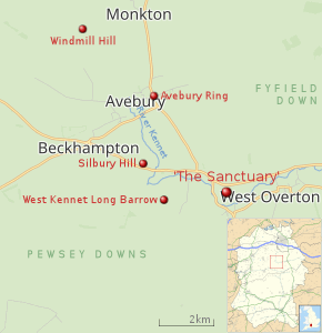 |
| Map with location of West Kennet Long Barrow, Wiltshire, and nearby Neolithic sites |
The Sanctuary is located at Ordnance Survey mapping six-figure grid reference SU 118679 at postcode SN8 1EY. The Sanctuary is open to the public, with concrete posts used to mark the positions of the stones and timbers. It is an English Heritage guardianship property, with lay-by parking and interpretation boards. The only visible remains are the concrete markers.[2]
Images
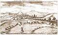 The Sanctuary by William Stukeley, 1723
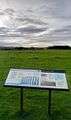 Information board
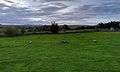 Where the Sanctuary joins West Kennet Avenue
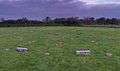
References
- 1 2 "Avebury: The Sanctuary". The Heritage Journal. 28 February 2010. Retrieved 5 March 2018.
- 1 2 3 4 5 "History of the Sanctuary, Avebury". english-heritage.org.uk. 2006. Retrieved 5 March 2018.
- ↑ "Stonehenge, Avebury and Associated Sites". whc.unesco.org. 1986. Retrieved 5 March 2018.
- 1 2 3 "The Sanctuary: HER id 4743". Wiltshire and Swindon Historic Environment Record. Retrieved 5 March 2018.
- ↑ stukeley sanc
- ↑ silbaby
- ↑ Mrs. M. E. Cunnington (1930). "The "Sanctuary" on Overton Hill, near Avebury". Wiltshire archaeological and natural history magazine. 45: 300–335.
- ↑ Dames, Michael 1977 The Avebury Cycle Thames & Hudson Ltd, London
- Vatcher, Faith de M & Vatcher, Lance 1976 The Avebury Monuments - Department of the Environment HMSO
External links
| Wikimedia Commons has media related to The Sanctuary, Avebury. |
- grid reference SU118679
- The Sanctuary revisited (scroll down)
- Avebury Sanctuary Stroll, National Trust 1 mile walk.