The Rip
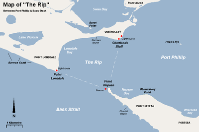
"The Rip", also known as "The Heads", is a dangerous stretch of water in Victoria, Australia, connecting Port Phillip and Bass Strait. It is the only entrance for shipping into Port Phillip and hence into Melbourne. Because of large tidal flows through the relatively narrow channel from the bay to the ocean, and a high rocky seabed, The Rip has claimed many ships and lives. Geographically, it is the roughly triangular area of water between the land points of Point Nepean, Shortlands Bluff and Point Lonsdale, these 3 form The Heads.
Geography
The Rip is generally considered to be located in the triangular area of water between the land points of Point Nepean, Shortlands Bluff and Point Lonsdale. The entrance between Point Lonsdale and Point Nepean is 3.5 km wide but the reefs projecting from these points reduce the navigable width to about 1 km. Within 800m outside the Heads, there is a shallow rocky flat known as the Rip Bank. The water deepens outside this flat to 30m and inside the Heads to as much as 90 m. This inequality of depth combined with tidal streams running up to 6 knots, causes the world-renowned dangerous conditions. The variation in seafloor depth within the rip itself can be anywhere from 100m to less than 5m amongst the rocky reefs and shoals.

Navigation
The area of The Rip is a navigation hazard for recreational and small commercial vessels, due to strong tidal movements, unpredictable waves and proximity to active shipping lanes. Vessels are also prohibited from landing at Point Nepean on the southern central border of The Rip.[1]
Control of shipping movements through the heads is managed by the Point Lonsdale Signal Station. Large ships may only enter Port Phillip with a qualified pilot aboard to help them navigate through the heads.[2] The heads are very narrow, having a width of approximately two kilometres. When entering, large ships have to follow a precise S-shaped course through the heads. The Queenscliff Low Light ("white lighthouse") and Queenscliff High Light ("black lighthouse") form a leading line to guide ships through the main channel, in conjunction with the Hume and Murray Towers that show red and green lights respectively.
Swim crossing
Douglas Mew was the first person to swim across the Rip, on 13 June 1971. He completed the swim without a cage, in a time of 61 minutes. This achievement is commemorated by a plaque on the Point Lonsdale side of the Rip.[3]
References
- ↑ "Guide to Port Phillip" (PDF). Parks Victoria. 2012. Retrieved 2013-09-22.
- ↑ History, Port Phillip Sea Pilots, retrieved 2011-10-22
- ↑ Design, UBC Web. "Douglas Mew | Monument Australia". monumentaustralia.org.au. Retrieved 2017-02-07.
External links
![]()
Coordinates: 38°17′15″S 144°38′14″E / 38.28750°S 144.63722°E