The Ramparts (Canada)
| The Ramparts | |
|---|---|
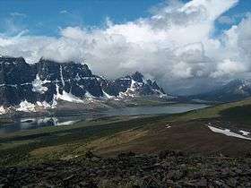 The Ramparts and Amethyst Lake in Jasper National Park | |
| Highest point | |
| Coordinates | 52°42′35″N 118°21′33″W / 52.70972°N 118.35917°WCoordinates: 52°42′35″N 118°21′33″W / 52.70972°N 118.35917°W [1] |
| Dimensions | |
| Area | 83 km2 (32 sq mi) |
| Geography | |
| Country | Canada |
| Provinces | Alberta and British Columbia |
| Parent range | Continental Ranges |
The Ramparts are a mountain range in the Canadian Rockies. Part of the Park Ranges, they straddle the Continental Divide and lie partly within Jasper National Park in Alberta and Mount Robson Provincial Park in British Columbia.
There are 10 named summits in the group. They were named by the Alpine Club of Canada and carry military engineering themed names such as Bastion, Parapet, and Dungeon.[2] They form a western boundary for the Tonquin Valley. Amethyst Lake lies to the east, while the headwaters of the Fraser River bound it to the west.[3]
References
- ↑ "The Ramparts". BC Geographical Names.
- ↑ Boles, Glen W.; Laurilla, Roger W.; Putnam, William L. (2006). Canadian Mountain Place Names. Vancouver: Rocky Mountain Books. ISBN 978-1-894765-79-4.
- ↑ "Panorama of the entire Ramparts". Bivouac.com. Retrieved 14 April 2012.
This article is issued from
Wikipedia.
The text is licensed under Creative Commons - Attribution - Sharealike.
Additional terms may apply for the media files.