Thalheim bei Wels
| Thalheim bei Wels | ||
|---|---|---|
 | ||
| ||
 Thalheim bei Wels Location within Austria | ||
| Coordinates: 48°09′05″N 14°02′18″E / 48.15139°N 14.03833°ECoordinates: 48°09′05″N 14°02′18″E / 48.15139°N 14.03833°E | ||
| Country | Austria | |
| State | Upper Austria | |
| District | Wels-Land | |
| Government | ||
| • Mayor | Andreas Stockinger (ÖVP) | |
| Area | ||
| • Total | 16 km2 (6 sq mi) | |
| Elevation | 369 m (1,211 ft) | |
| Population (14 June 2016)[1] | ||
| • Total | 5,498 | |
| • Density | 340/km2 (890/sq mi) | |
| Time zone | UTC+1 (CET) | |
| • Summer (DST) | UTC+2 (CEST) | |
| Postal code | 4600 | |
| Area code | 07242 | |
| Vehicle registration | WL | |
| Website | www.thalheim.ooe.gv.at | |

Thalheim bei Wels is a town in the Wels-Land district in the Austrian state of Upper Austria.
Geography
It is situated on the right bank of the river Traun, opposite the city of Wels. About 11.6% of the municipality is forest, 69% is farmland.
Subdivisions
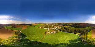
360° airborne panorama, shot in Ottstorf
show as 360° surround photography
show as 360° surround photography
- Bergerndorf
- Edtholz
- Ottstorf
- Schauersberg
- Thalheim bei Wels
- Unterschauersberg
Population
| Historical population | ||
|---|---|---|
| Year | Pop. | ±% |
| 1991 | 4,525 | — |
| 2001 | 4,971 | +9.9% |
| 2013 | 5,470 | +10.0% |
Sights
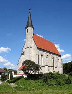
- Pilgrimage church Maria Schauersberg, consecrated around 1490.
- Marienwarte, a 19th-century observation tower, offers a panorama of the surrounding country. On clear days, the Alps can be seen.
Personalities
- Franz Kalchmair (b. 1939), an opera singer.
References
| Wikimedia Commons has media related to Thalheim bei Wels. |
This article is issued from
Wikipedia.
The text is licensed under Creative Commons - Attribution - Sharealike.
Additional terms may apply for the media files.