Texas State Highway 347
| ||||
|---|---|---|---|---|
 | ||||
| Route information | ||||
| Maintained by TxDOT | ||||
| Length | 11.441 mi[1] (18.413 km) | |||
| Existed | 1942–present | |||
| Major junctions | ||||
| South end |
| |||
| North end |
| |||
| Highway system | ||||
| ||||

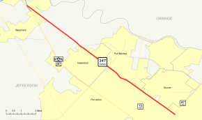
State Highway 347 or SH 347 is a Texas state highway that runs northwest from Port Arthur to the southern edge of Beaumont. The highway is signed south-north. It was designated on November 25, 1942 along the old route of US 69.
Route description
SH 347 begins at SH 87 in Port Arthur. The highway heads northwest, crossing SH 73, Spur 136 and FM 365. SH 347 then enters Nederland and has a junction with FM 366. Continuing northwest, the highway enters Beaumont and ends at US 69/US 96/US 287 in the southern end of the city.
Junction list
The entire route is in Jefferson County.
| Location | mi | km | Destinations | Notes | |
|---|---|---|---|---|---|
| Port Arthur | |||||
| Interchange | |||||
| | |||||
| | |||||
| Beaumont | Interchange | ||||
| 1.000 mi = 1.609 km; 1.000 km = 0.621 mi | |||||
References
- ↑ Transportation Planning and Programming Division (n.d.). "State Highway No. 347". Highway Designation Files. Texas Department of Transportation. Retrieved 2008-04-02.
This article is issued from
Wikipedia.
The text is licensed under Creative Commons - Attribution - Sharealike.
Additional terms may apply for the media files.