Terrett Butte
| Terrett Butte | |
|---|---|
| Turret Buttes, Twin Buttes | |
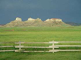 Terrett Butte, 2006 | |
| Highest point | |
| Elevation | 3,530 ft (1,080 m) |
| Coordinates | 45°14′53″N 105°37′21″W / 45.248°N 105.6225°WCoordinates: 45°14′53″N 105°37′21″W / 45.248°N 105.6225°W [1] |
| Geography | |
 Terrett Butte | |
Terrett Butte is a prominent landmark on the east side of the Powder River in Powder River County, Montana.
History
The first time the Terrett Butte was mentioned in writing was on September 12, 1865, in the diary of Major Lyman G. Bennett, the chief engineering officer accompanying Colonel Nelson D. Cole's column of the Powder River Expedition. [2] Bennett wrote:
Marched on west side of Powder River, crossing in the morning. The road was generally good, being on second bottom with high rocky mountains on either side the valley, the tops of many being covered with pine. The scenery was truly romantic. The mountains being high and worn into many fantastic shapes, such as ruins, castles, etc.
Location
Terrett Butte is located on private land, about two hundred yards east of East River Road South, about 17 miles (27 km) south of present-day Broadus, Montana, in Powder River County, Montana.
References
- ↑ "Terrett Butte". Geographic Names Information System. United States Geological Survey. Retrieved July 17, 2014.
- 1 2 Wagner, David E.; Bennett, Lyman G. (2009). Powder River Odyssey: Nelson Cole's Western Campaign of 1865, The Journals of Lyman G. Bennett and Other Eyewitness Accounts. Arthur H. Clark Co. ISBN 978-0-87062-370-7.