Tenmabayashi, Aomori
| Tenmabayashi 天間林村 | |
|---|---|
| Former municipality | |
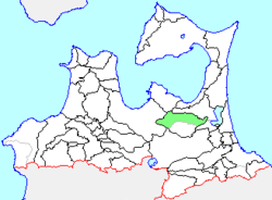 Location of Tenmabayashi in Aomori Prefecture | |
 Tenmabayashi Location in Japan | |
| Coordinates: 40°44′40.7″N 141°09′27.3″E / 40.744639°N 141.157583°ECoordinates: 40°44′40.7″N 141°09′27.3″E / 40.744639°N 141.157583°E | |
| Country | Japan |
| Region | Tōhoku |
| Prefecture | Aomori Prefecture |
| District | Kamikita |
| Merged |
March 31, 2005 (now part of Shichinohe) |
| Area | |
| • Total | 202.59 km2 (78.22 sq mi) |
| Population (January 1, 2005) | |
| • Total | 8,354 |
| • Density | 41.23/km2 (106.8/sq mi) |
| Symbols | |
| • Tree | Zelkova serrata |
| • Flower | Japanese bellflower |
| • Bird | Green pheasant |
| Time zone | UTC+9 (JST) |
Tenmabayashi (天間林村 Tenmabayashi-mura) was a village located in Kamikita District in central Aomori Prefecture, Japan.
Tenmabayashi Village was founded in 1889 from the merger of seven small hamlets.
On March 31, 2005, Tenmabayashi was merged into the neighboring and expanding town of Shichinohe, and thus no longer exists as an independent municipality.
Located in central Aomori prefecture, the village of Tenmabashi had an economy based on primarily on agriculture, with principal crops including rice, garlic and Japanese yam.
At the time of its merger, the village had an estimated population of 8,354 and a density of 41.23 persons per km2. The total area was 202.59 km2.
Tenmabayashi was served by Route 4 (Japan) and Route 394 (Japan) highways, but had no railway service.