Tengréla
| Tengréla Tingréla | |
|---|---|
| Town, sub-prefecture, and commune | |
 Tengréla Location in Ivory Coast | |
| Coordinates: 10°29′N 6°24′W / 10.483°N 6.400°WCoordinates: 10°29′N 6°24′W / 10.483°N 6.400°W | |
| Country |
|
| District | Savanes |
| Region | Bagoué |
| Department | Tengréla |
| Population (2014)[1] | |
| • Total | 80,887 |
| Time zone | UTC+0 (GMT) |
Tengréla (also spelled Tingréla) is a town in the far north of Ivory Coast. It is a sub-prefecture and the seat of Tengréla Department in Bagoué Region, Savanes District. Tengréla is also a commune.
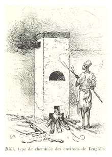
Dibi, a type of chimney used in Tingréla, 1892
The French explorer René Caillié stopped at the settlement of Tengréla, which was then a large walled village, in January 1828 on his journey to Timbuktu. He was travelling with a caravan of 500 to 600 people and 80 donkeys transporting kola nuts. In his book Travels through Central Africa to Timbuctoo published in 1830, he spelled the name of the village as "Tangrera".[2][3]
Notes
- ↑ "Côte d'Ivoire". geohive.com. Retrieved 7 December 2015.
- ↑ Caillié 1830, pp. 379-388.
- ↑ Viguier 2008, p. 27.
References
- Caillié, René (1830). Travels through Central Africa to Timbuctoo; and across the Great Desert, to Morocco, performed in the years 1824-1828 (Volume 1). London: Colburn & Bentley.
- Viguier, Pierre (2008). Sur les Traces de René Caillié: Le Mali de 1828 Revisité. Versailles, France: Quae. ISBN 978-2-7592-0271-3. .
Regional seat: Boundiali | ||
| Boundiali Department |  | |
| Kouto Department | ||
| Tengréla Department | ||
* also a commune | ||
This article is issued from
Wikipedia.
The text is licensed under Creative Commons - Attribution - Sharealike.
Additional terms may apply for the media files.