Sultan Ahmad Shah Bridge
| Sungai Pahang Bridge Jambatan Sultan Ahmad Shah (Jambatan Temerloh) | |
|---|---|
 | |
| Coordinates | 3°26′39″N 102°25′37″E / 3.444224°N 102.427007°ECoordinates: 3°26′39″N 102°25′37″E / 3.444224°N 102.427007°E |
| Carries | Motor vehicles, Pedestrians |
| Crosses | Pahang River |
| Locale |
|
| Official name |
Sultan Ahmad Shah Bridge (Temerloh Bridge) |
| Maintained by | Malaysian Public Works Department (JKR) Temerloh |
| Characteristics | |
| Design | steel viaduct |
| Total length | 575 m |
| Width | -- |
| Longest span | -- |
| History | |
| Designer |
Government of Malaysia Malaysian Public Works Department (JKR) |
| Constructed by | Malaysian Public Works Department (JKR) |
| Opened | 1974 |
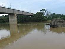
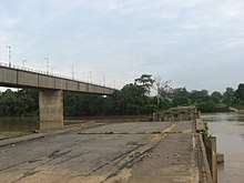
Sultan Ahmad Shah Bridge or Temerloh Bridge is the main bridge on Pahang River near Temerloh, Pahang, Malaysia. The 575 m bridge is located at Federal route ![]()
History
In 1971, the old Temerloh Bridge spanning across the Pahang River collapsed due to a massive flood in Temerloh. As a result, the Public Works Department (JKR) constructed a 575-m replacement bridge known as the Sultan Ahmad Shah Bridge FT2 beside the old bridge.[1] The Sultan Ahmad Shah Bridge is much higher than the old bridge, forming the first grade-separated interchange in Pahang that links to the Federal Route 10. The new bridge also links to a new road that bypasses Temerloh and Mentakab townships, causing the former Temerloh-Mentakab section to be re-gazetted as the Federal Route 87.[2] The construction of the Sultan Ahmad Shah Bridge was completed in 1974.[1]
References
- 1 2 "Gambar Pembinaan Sultan Ahmad Shah Temerloh Pahang". Aku Anak Pahang (in Malay). 2014-10-11. Retrieved 2015-06-25.
- ↑ "Ulang tahun ke-100 Jalan Persekutuan 2: Sejarah lengkap jalan FT2". Blog Jalan Raya Malaysia (in Malay). 2015-06-25. Retrieved 2015-06-26.
See also
- Sultan Ahmad Shah II Bridge (Semantan Bridge)
- Sultan Ahmad Shah III Bridge (Chenor Bridge)