Temštica
| Temštica | |
|---|---|
 | |
| Country | Serbia |
| Physical characteristics | |
| River mouth |
Nišava 43°12′28″N 22°30′16″E / 43.2077°N 22.5044°ECoordinates: 43°12′28″N 22°30′16″E / 43.2077°N 22.5044°E |
| Basin features | |
| Progression | Nišava→ South Morava→ Great Morava→ Danube→ Black Sea |
Temštica (Serbian: Темштица) is a river in Serbia, a right tributary of the river Nišava. The Temštica itself is not very long (23 km), but receives a much longer tributary, the Visočica (Височица), flowing from Bulgaria (16.7 km in length), thru Serbia (54 km in length) making Visočica and Temštica river system 93.7 km long.
Temštica (Toplodolska reka)
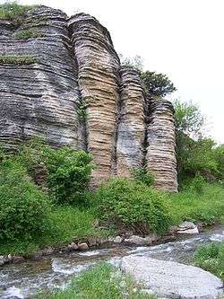
The Temštica, known as the Topli Do river (Toplodolska reka, Топлодолска река) in the northern part, originates from five streams from the Stara Planina mountain on the Serbian–Bulgarian border. Three major streams spring out from several peaks of Stara Planina: Midžor/Midzhur (Миџор/Миджур), Vražija Glava/Vrazha glava (Вражија Глава/Вража глава), Bratkova Strana (Браткова Страна) and Gola Glava (Гола Глава). They all join together near the village of Topli Dol, which gives the alternative name to the river. Temštica carved a canyon, popularly nicknamed "Little Colorado". The river continues to the northwest and receives the Visočica from the left.
In 1990, a tunnel was built to conduct 90% of the Visočica's water back into the Lake Zavoj. That left Temštica itself without 70% of the water, leaving only the "biological minimum" to overspill from the dam. However, that is the so-called "dead water", which comes from the depth of 60 m (200 ft) and has the temperature of only few Celsius degrees. Without any research being conducted, in 1992 the construction of the tunnel which would conduct the waters from Temštica itself into the Lake Zavoj began. As the area of Stara Planina was protected in the meantime the project was halted.[1][2]
Local population in the watershed of Temštica protested claiming that over 70% of the water was already taken out of Temštica which will result in an ecological catastrophe, especially in the canyon of Little Colorado. As a result of this, municipality of Pirot officially opposed the government's decision in 2004 and 2006, but the government insisted on continuing the project. In protest, population of the village of Temska boycotted the Serbian parliamentary elections in January 2007.[3] Due to the continued opposition from both the municipality and the population, the construction of the 9 km (5.6 mi) long tunnel which would transfer the water from the river into the lake was abandoned. The water of Visočica is already being transferred into the lake, so the Temska relies only on waters from the Temštica. Transferring that water into the lake would make riverbeds downstream almost dry and lifeless. In the winter of 2017, the government announced that it will continue the construction of the tunnel, promising they will leave "the minimal needed amount" of water in the river. This prompted further popular protests.[1]
Visočica
The Visočica or Visochitsa (Височица) is 71-kilometre-long (44 mi), originating from the mountain of Berkovska Planina, a part of Stara Planina, near Kom Peak, just a few kilometers away from the Serbian border. The river, in this section known also as Barlska Reka from the name of the village of Barlya, flows to the south, reaching the Zabardie region of eastern Bulgaria and the northern slopes of the Gora mountain, where it turns west and enters the Visok depression at the village of Komshtitsa. Soon after it turns west, the Visočica crosses the Bulgarian-Serbian border.
The Visok depression is located between Stara Planina to the north and the Vidlič (or Vidlich) mountain to the south. It is elongated (divided into upper and lower sections) and sparsely populated: the villages of Izatovci, Slavinja (where it receives the tributary of Rosomačka reka from the right), Visočka Ržana (where it receives the tributary of the Dojkinička reka, also from the right), Rsovci, Pakleštica, Velika Lukanja and former village of Zavoj, before it meets the Temštica.
The Visočica is the source of the drinking water for the region and the habitat of the protected noble crayfish.[4]
In 1963 a huge landslide jammed the river, creating a natural earth dam (500 m (1,600 ft) long and 50 m (160 ft) high) which in turn created a lake that flooded the village of Zavoj. The natural lake was dried, the dam was consolidated and a hydroelectrical power plant was constructed (HE Zavoj) with the artificial Lake Zavoj (area5.53 km2 (2.14 sq mi); altitude 612 m (2,008 ft); depth 60 m (200 ft)) instead of the dried one. The village of Novi Zavoj was built on higher ground for the residents of the flooded Zavoj.
Just as with the Temštica, Visočica and its tributaries were seen as a location for dozens of micro hydros, mini power plants and again, it caused problem with the environmentalists and local population. Construction of the proposed Pakleštica micro hydro was halted by the Ministry for environmental protection after "Srbijašume" state owned company reported that the power plant would disrupt the ecology of the area. Additionally, the region of Stara Planina is protected by the law. The Administrative Court then confirmed the investors' rights to build the plant, but the Ministry appealed to the Supreme Court of Cassation and announced the change of the Nature protection law, which will permanently forbid the construction of plants in protected areas. In order to prevent further degradation, the Nature Park Stara Planina was nominated for the UNESCO's Man and the Biosphere Programme and for the world list of geoparks, while over 10,000 citizens signed petition against the micro hydros, including the deans of several faculties within the University of Belgrade (Biology, Forestry, Veterinary Medicine) and organized protests.[4][5]
Temska
In the final, 15-kilometre-high (9 mi) section after the confluence with the Visočica, the Temštica is also known as the Temska . The river flows next to the village of Novi Zavoj and the Monastery of Temska (with the small hydroelectrical power plant of the same name) and empties into the Nišava northwest of the town of Pirot.
The Temštica drains an area of 820 km2 (320 sq mi), it belongs to the Black Sea drainage basin and it is not navigable.
As with the both rivers which form the Temska, there are environmental concerns stemming from the 2008 plan to build 60 micro hydros in the Stara Planina region. The worst effects are created by the derivative hydro plants. In such cases, the 2 to 4 km (1.2 to 2.5 mi) long pipes which redirect the flow are being laid. As they are all privately owned, the owners often redirect all the water in the pipes. They are not even leaving the biological minimum which is too low to begin with, since those are not major flows, instead the lower courses of the streams dry completely. The inhabitants self-organized into various environmental groups. When construction of such a micro hydro began on the Rudinjska Reka, a tributary to the Temska, the construction workers rerouted the river completely, some 300 m (980 ft) from its mouth. However, the redirected water reached a sinkhole and began to descend, leaving the river completely dry. Members of one of the organizations gathered in August 2018 and, without any permissions, dug a channel which bypassed the river back into its natural riverbed.[6]
References
- 1 2 R.Džunić (19 July 2017), "Molitva za spas reke na Staroj planini", Politika (in Serbian), p. 22
- ↑ Slavica Stuparušić (29 August 2017), "Da Stara planina ne ostane žedna", Politika (in Serbian), p. 08
- ↑ Politika, 22 January 2007, page 06
- 1 2 Slavica Stuparušić (21 August 2018). "Meštani i ekolozi nastavljaju da se bore za Visočicu na Staroj planini" [Denizens ad ecologists continue to fight for the Visočica and Stara Pazova]. Politika (in Serbian). p. 08.
- ↑ Gordana Bjeletić (2 September 2018). "Protest u Pirotu protiv mini hidroelektrana: Ne damo reke" [Protest in Pirot against the micro hydros: we are not giving our rivers away] (in Serbian). N1.
- ↑ Slavica Stuparušić (28 August 2018). "Rudinjska reka vraćena u korito" [Rudinjska Reka is returned to its riverbed]. Politika (in Serbian). p. 08.
Sources
External links
| Wikimedia Commons has media related to Temštica. |