Tecoanapa (municipality)
| Tecoanapa | ||
|---|---|---|
| Municipality | ||
| ||
|
Tecoanapa Location in Mexico | ||
| Coordinates: 16°48′N 99°09′W / 16.800°N 99.150°WCoordinates: 16°48′N 99°09′W / 16.800°N 99.150°W | ||
| Country |
| |
| State | Guerrero | |
| Municipal seat | Tecoanapa | |
| Area | ||
| • Total | 776.9 km2 (300.0 sq mi) | |
| Population (2005) | ||
| • Total | 42,619 | |
.png)
Tecoanapa is one of the 81 municipalities of Guerrero, in south-western Mexico. The municipal seat lies at Tecoanapa. The municipality covers an area of 776.9 square kilometres (300.0 sq mi).
In 2005, the municipality had a population of 42,619.[1]
Gallery
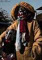 Danzante Tlacololero and his son in Las Ánimas, Municipality of Tecoanapa, Guerrero. Mex.
 Dance of "Los Diablos". Las Ánimas, Municipality of Tecoanapa, Guerrero, Mex.
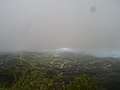 Los Magueyitos, small town in the municipality of Tecoanapa.
References
- ↑ "Tecoanapa". Enciclopedia de los Municipios de México. Instituto Nacional para el Federalismo y el Desarrollo Municipal. Retrieved December 23, 2008.

This article is issued from
Wikipedia.
The text is licensed under Creative Commons - Attribution - Sharealike.
Additional terms may apply for the media files.